Exploring the Pečica Pass: Motorcycling the 219 Route from Slovenska Bistrica to Čatež ob Savi
Locals know best!
If you travel this road often or live close by you will be given a chance to provide your valuable rating soon! Sign in and stay connected.Location and Overview of the 219 Pečica Pass Route
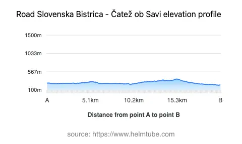
The 219 Pečica Pass Route is situated in eastern Slovenia, beginning near the town of Slovenska Bistrica and extending towards Čatež ob Savi. The road passes through several settlements, including Križni vrh, Spodnja Brežnica, Videž, and Podplat, before reaching its terminus. The route is notable for crossing the Pečica mountain pass at an elevation of 377 m (1,237 ft), providing a connection between the Drava and Sava river basins. The region is characterized by rolling hills and forms part of the broader Alpine landscape, intersecting both the Alps and the Karawanken und Bachergebirge mountain ranges. An interactive map showing the road can be found at the end of the article.
Road Characteristics and Riding Experience
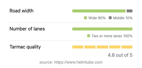
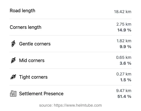
The 219 Pečica Pass Route covers a distance of approximately 18.4 km (11.4 miles), with the majority of the road classified as wide (about 89%), ensuring comfortable passage for two-way traffic. The surface is asphalt and is generally rated as excellent, providing a smooth and predictable riding experience. The road is not particularly twisty, featuring gently curved sections that allow for a relaxed pace, though riders should remain attentive in inhabited areas, which account for just over half of the route. The elevation ranges from 228 m (748 ft) at its lowest point to 382 m (1,253 ft) at its highest, with the Pečica Pass itself situated at 377 m (1,237 ft). The road is consistently two lanes throughout its length, supporting steady traffic flow.
Points of Interest Along the Route
While the 219 Pečica Pass Route is primarily valued for its riding quality, it also provides access to several local attractions. Slovenska Bistrica, the nearest town to the starting point, is known for its historic Slovenska Bistrica Castle and vibrant town center. At the other end, Rogaška Slatina is renowned for its spa culture and mineral springs, particularly the Rogaška Slatina Spa. The route itself traverses the foothills of the Alps and the Karawanken, offering views of the surrounding landscape. Riders may also wish to explore the smaller settlements along the way, each with its own local character and amenities.
Practical Information: Closures, Tolls, and Regulations
The 219 Pečica Pass Route is open to motorcycles year-round, with no regular seasonal closures reported. However, temporary closures may occur due to roadworks or local events, so it is advisable to check for updates before planning a trip. There are currently no tolls or entrance fees required for motorcycles on this section of road. Riders should be aware that toll conditions may change in the future; for the most current information on road tolls and fees in Slovenia, consult the official DARS website. Speed limits along the route vary between 50 km/h (31 mph) in inhabited areas and up to 90 km/h (56 mph) on open stretches. Adherence to posted speed limits and local traffic regulations is essential for safety and compliance.
Route Planning and Map Resources
For those planning to ride the 219 Pečica Pass Route, it is recommended to review detailed maps and local travel guides. The road's moderate length and gentle curves make it suitable for riders of varying experience levels. Facilities such as fuel stations and rest stops are available in the larger towns at either end of the route. An interactive map of the 219 Pečica Pass Route is available below to assist with trip planning and navigation.
Explore the Region: Roads Close By
Discover more amazing roads located near the route featured in this article. The list below highlights nearby routes that are perfect for extending your ride or planning your next adventure.
Ride the Best: Slovenia’s Top Motorcycle Roads
These are the best motorbiking roads in Slovenia. The list below shows links to articles about top-rated motorcycle routes in the country. Explore the most popular roads in Slovenia and plan your next unforgettable motorbike adventure.