Exploring the 671 Križaj–Planina v Podbočju Route: A Motorcyclist’s Guide
Locals know best!
If you travel this road often or live close by you will be given a chance to provide your valuable rating soon! Sign in and stay connected.Location and Geographic Context
The 671 Križaj–Planina v Podbočju road is situated in southeastern Slovenia, close to the border with Croatia. The route runs near the town of Kostanjevica na Krki, a settlement known for its historical and cultural significance. The road skirts the edge of Park prirode Žumberak – Samoborsko gorje, a protected area recognized for its diverse flora, fauna, and karst landscapes. The region is characterized by rolling hills, forested sections, and agricultural land, providing a varied backdrop for motorcyclists. An interactive map showing the precise route of the 671 Križaj–Planina v Podbočju road can be found at the end of this article.
Road Characteristics and Riding Experience
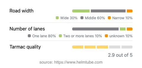
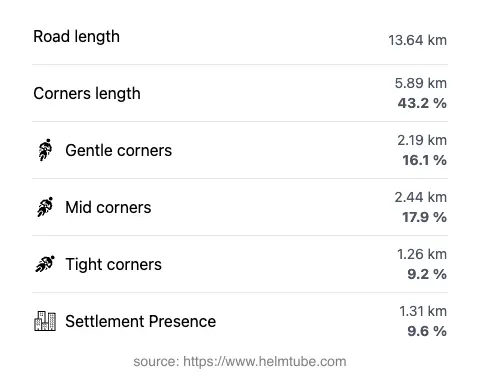
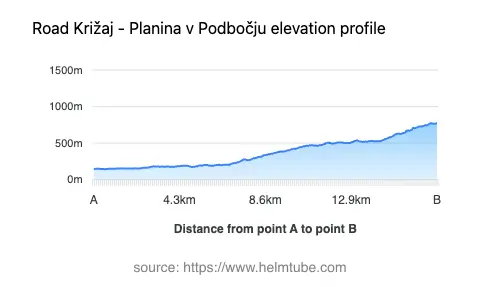
The 671 Križaj–Planina v Podbočju route extends for approximately 13.6 km (8.5 miles), with elevations ranging from 144 m (472 ft) to 776 m (2,546 ft). The road is predominantly surfaced with asphalt, though the surface quality is moderate and may present occasional rough patches. Riders will encounter a mix of gently curved and moderately twisty sections, making it suitable for those who appreciate a varied riding experience without extreme technical demands. The road is primarily single-lane (about 83%), with some stretches offering two lanes (about 15%). In terms of width, the majority of the route is of medium width (about 59%), with narrower segments (13%) and some wider portions (27%). Only a small proportion of the road (9.6%) passes through inhabited areas, allowing for an uninterrupted ride through rural and natural settings.
Points of Interest and Attractions
While the road itself is not widely known by a specific nickname among motorcyclists, its proximity to Park prirode Žumberak – Samoborsko gorje is a significant draw. This protected area is renowned for its biodiversity, hiking trails, and traditional rural architecture. The nearby town of Kostanjevica na Krki is also worth a visit, offering cultural sites such as the Kostanjevica Monastery and the Božidar Jakac Art Museum. Riders interested in exploring local heritage will find these attractions accessible from the route. The road’s location near the Slovenian-Croatian border adds an element of cross-border exploration, with opportunities to experience both Slovenian and Croatian landscapes and communities.
Seasonal Closures, Road Access, and Regulations
There are currently no permanent closures for motorcycles on the 671 Križaj–Planina v Podbočju road. However, as the route passes near and partially skirts a protected natural area, riders should be aware of potential temporary restrictions related to park management or local events. The road is not subject to regular winter closures, but adverse weather conditions, particularly in higher elevations, may impact accessibility during the colder months. It is advisable to check local sources or the official Slovenian traffic information portal for up-to-date information on road conditions and any event-related closures before planning a trip.
Tolls, Fees, and Practical Information
There are no tolls or entrance fees required to ride the 671 Križaj–Planina v Podbočju road at this time. However, toll conditions and access regulations may change in the future, especially given the road’s proximity to a protected area. For the most current information regarding road tolls and entrance fees in Slovenia, riders should consult the DARS vignette information page. It is recommended to verify requirements before travel, particularly if planning to cross into Croatia or visit additional protected areas.
Explore the Region: Roads Close By
Discover more amazing roads located near the route featured in this article. The list below highlights nearby routes that are perfect for extending your ride or planning your next adventure.
Ride the Best: Slovenia’s Top Motorcycle Roads
These are the best motorbiking roads in Slovenia. The list below shows links to articles about top-rated motorcycle routes in the country. Explore the most popular roads in Slovenia and plan your next unforgettable motorbike adventure.