Exploring the 704 Radlje–Ribnica–Brezno Route: A Motorcyclist’s Guide Through the Slovenian Alps
Locals know best!
If you travel this road often or live close by you will be given a chance to provide your valuable rating soon! Sign in and stay connected.Location and Geographic Context
The 704 Radlje–Ribnica–Brezno road is situated in northern Slovenia, within the broader Alpine region. The route links the settlements of Ribnica na Pohorju and Podvelka, running through the Drava River valley and intersecting several notable mountain ranges, including the Alps, Karawanken und Bachergebirge, and Lavanttaler Alpen. The road’s proximity to the Drava River adds to its geographical significance, although only a small portion of the route runs directly alongside the river. An interactive map showing the precise alignment of the road can be found at the end of this article.
Road Characteristics and Riding Experience
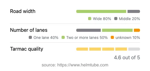
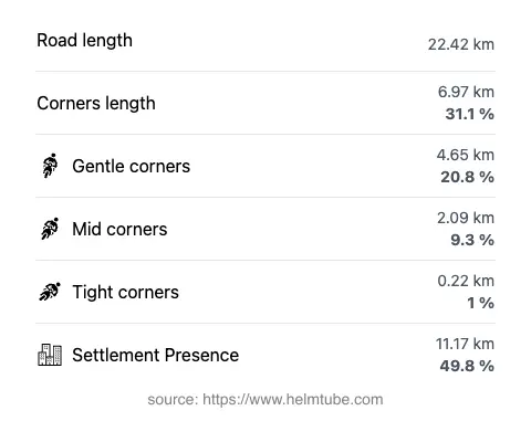
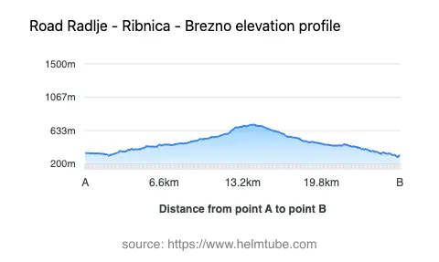
The 704 Radlje–Ribnica–Brezno route extends for approximately 22.4 km (13.9 miles), offering a moderately curvy riding experience. The road surface is asphalt and is generally of high quality, with most sections rated as very good. Riders will encounter a mix of one-lane and two-lane segments, with two-lane sections making up the largest proportion (about 46%). The road is predominantly wide (about 76%), providing ample space for maneuvering, while narrower stretches are limited. The elevation ranges from 291 m (955 ft) at its lowest point to 712 m (2,336 ft) at its highest, resulting in moderate altitude changes that add to the technical interest of the ride. The route passes through both inhabited and rural areas, with nearly half of its length traversing settlements, which may influence traffic density and speed limits. The maximum permitted speed varies between 40 km/h (25 mph) and 50 km/h (31 mph), reflecting the road’s alignment and the presence of populated zones.
Natural Features and Points of Interest
While the 704 Radlje–Ribnica–Brezno road is not widely known by a specific nickname among motorcyclists, its passage through the Slovenian Alps and adjacency to the Drava River make it notable. The route offers access to the foothills of the Alps and the Lavanttaler Alpen, regions known for their natural beauty and outdoor recreation opportunities. The settlements of Ribnica na Pohorju and Podvelka serve as gateways to local hiking trails and forested landscapes. Although the road itself does not directly connect to major tourist attractions, its location makes it a practical link for riders seeking to explore the broader alpine environment of northern Slovenia.
Seasonal Accessibility and Road Regulations
The 704 Radlje–Ribnica–Brezno road is generally open to motorcycles year-round, with no regular seasonal closures reported. However, as with many alpine routes, winter conditions can affect accessibility due to snow or ice, particularly at higher elevations. Riders should monitor local weather forecasts and road maintenance updates before planning a trip during colder months. There are no known event-related closures that regularly impact this route, but temporary restrictions may occur due to roadworks or local events. It is advisable to consult the Slovenian Traffic Information Center for current road status before departure.
Tolls, Fees, and Practical Information
There are currently no tolls or entrance fees required for motorcycles on the 704 Radlje–Ribnica–Brezno road. Riders should be aware that toll conditions may change in the future, and it is recommended to verify the latest information through the DARS (Slovenian Motorway Company) website, which provides up-to-date details on tolls and vignettes for Slovenia. Standard road rules apply, including adherence to posted speed limits and traffic regulations. Services such as fuel stations and food outlets are limited along the route, so planning ahead is advisable, especially for longer rides through the region.
Explore the Region: Roads Close By
Discover more amazing roads located near the route featured in this article. The list below highlights nearby routes that are perfect for extending your ride or planning your next adventure.
Ride the Best: Slovenia’s Top Motorcycle Roads
These are the best motorbiking roads in Slovenia. The list below shows links to articles about top-rated motorcycle routes in the country. Explore the most popular roads in Slovenia and plan your next unforgettable motorbike adventure.