Exploring the 744 Štore–Svetina–Laško Route: A Technical Ride Through Slovenia’s Alpine Foothills
Locals know best!
If you travel this road often or live close by you will be given a chance to provide your valuable rating soon! Sign in and stay connected.Location and Geographic Context
The 744 Štore–Svetina–Laško road is situated in eastern Slovenia, linking the settlements of Štore, Svetina, and Laško. The route begins near the city of Celje and ends close to the town of Laško, passing through Železarska cesta, Ulica Cvetke Jerin, and Kovinarska ulica. The road skirts the southern fringes of the Alps, specifically the Alps, Karavanke, and Karawanken und Bachergebirge mountain ranges. The Savinja River, a tributary of the Sava, runs adjacent to a small section of the route. An interactive map showing the road can be found at the end of the article.
Road Characteristics and Riding Experience
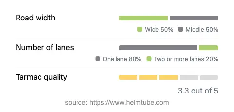
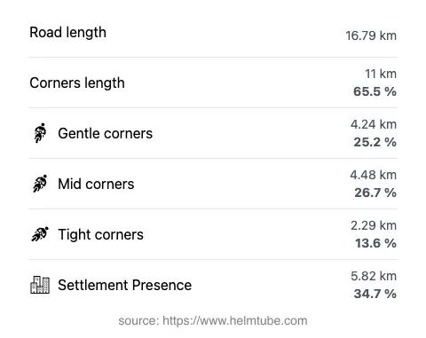
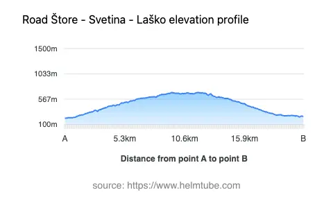
This road extends for approximately 16.8 km (10.4 miles), with elevations ranging from 218 m (715 ft) to 692 m (2,270 ft). The route is characterized by a very twisty alignment, offering a series of engaging curves that demand attention and skill from riders. The surface is asphalt, with a quality rating that can be described as moderate—neither poor nor excellent, but generally reliable for most motorcycles. The road width varies, with about 45% being wide, 48% of medium width, and a small portion (2%) classified as narrow. Most of the route is single-lane (about 77%), with two-lane sections making up roughly 20%. Approximately 35% of the road passes through inhabited areas, providing a mix of rural and semi-urban riding environments.
Natural Features and Points of Interest
The route’s proximity to the Savinja River adds a dynamic element to the ride, although only a small segment (6%) runs directly alongside the river. The road skirts the lower slopes of the Alps and the Karavanke range, offering occasional glimpses of mountainous terrain. Riders may wish to explore the spa town of Laško, known for its thermal baths and brewery, or the city of Celje, which features a medieval castle and a well-preserved old town. The settlement of Svetina, located along the route, is notable for its elevated position and traditional Slovenian rural architecture.
Road Access, Closures, and Fees
There are no known restrictions or seasonal closures for motorcycles on the 744 Štore–Svetina–Laško road. The route remains accessible throughout the year, although winter conditions may affect surface quality and traction, particularly at higher elevations. Riders should exercise caution during periods of snow or ice. There are currently no tolls or entrance fees required to use this road. However, toll conditions may change in the future. For the most up-to-date information on road tolls and entrance fees in Slovenia, consult the official DARS website.
Practical Considerations for Motorcyclists
Given the road’s curviness and variable width, riders should be prepared for frequent gear changes and attentive cornering. The moderate surface quality means that occasional potholes or uneven patches may be encountered, especially after winter. The mix of inhabited and rural sections requires vigilance for local traffic, agricultural vehicles, and pedestrians. Speed limits typically range from 50 km/h (31 mph) in built-up areas to 90 km/h (56 mph) in open stretches, but riders should always observe posted signage. Facilities such as fuel stations and cafes are available in Laško and Celje, while Svetina offers limited amenities. For those interested in extending their journey, the region provides access to additional Alpine routes and cultural attractions.
Explore the Region: Roads Close By
Discover more amazing roads located near the route featured in this article. The list below highlights nearby routes that are perfect for extending your ride or planning your next adventure.
Ride the Best: Slovenia’s Top Motorcycle Roads
These are the best motorbiking roads in Slovenia. The list below shows links to articles about top-rated motorcycle routes in the country. Explore the most popular roads in Slovenia and plan your next unforgettable motorbike adventure.