Riding the Ascher Pass: Puchberg am Schneeberg to Pernitz
Locals know best!
If you travel this road often or live close by you will be given a chance to provide your valuable rating soon! Sign in and stay connected.Location and Overview
The Ascher Pass road connects the towns of Puchberg am Schneeberg and Pernitz in Lower Austria, cutting through the Gutensteiner Alps and the Hohe Wand region. The route is situated in the eastern part of the Austrian Alps, an area known for its mountainous terrain and proximity to Vienna. The road begins near Puchberg am Schneeberg, a town recognized for its access to the Schneeberg mountain, and concludes in Pernitz, a gateway to the Myrafälle waterfalls and the Gutenstein Alps. An interactive map showing the road can be found at the end of the article.
Road Characteristics and Riding Experience
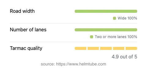
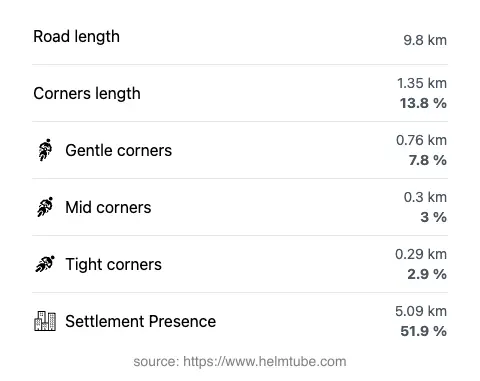
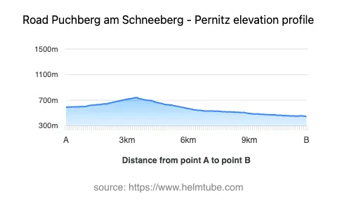
The Ascher Pass road extends for approximately 9.8 km (6.1 miles), with elevations ranging from 446 m (1,463 ft) at its lowest point to 741 m (2,431 ft) at the summit of the Ascher Pass. The road surface is asphalt and is generally of excellent quality, providing a smooth ride for most of its length. The route is predominantly wide (about 98%), with two lanes for the majority of the journey (about 97%), ensuring comfortable passage for both motorcycles and other vehicles. The road is moderately curvy, offering a mix of gently winding sections and more straightforward stretches, making it suitable for riders seeking a balance between technical riding and relaxed touring. The maximum speed limits along the route vary between 50 km/h (31 mph), 70 km/h (43 mph), and 100 km/h (62 mph), depending on the segment and proximity to inhabited areas. Approximately half of the road passes through or near settlements, with Ascherstraße being a notable waypoint along the way.
Mountain Pass and Surrounding Landscape
The highlight of this route is the crossing of the Ascher Pass, which sits at an elevation of 738.9 m (2,424 ft). The pass is a lesser-known but significant connector within the Gutensteiner Alps, providing access between the valleys and mountain communities. The road also briefly skirts the Eichtal valley and traverses the Hohe Wand, a prominent limestone ridge popular with hikers and climbers. The surrounding landscape is characterized by alpine forests, rocky outcrops, and occasional panoramic views of the Schneeberg massif. For those interested in the region's geography, the road intersects three notable mountain ranges: the Alps, the Hohe Wand, and the Gutensteiner Alps. The proximity to Puchberg am Schneeberg also makes it possible to visit the Schneeberg, the highest mountain in Lower Austria.
Access, Closures, and Practical Information
The Ascher Pass road is open to motorcycles and is not subject to regular seasonal closures. However, as with many alpine routes in Austria, temporary closures may occur due to adverse weather conditions, particularly in winter months when snow or ice can make the road impassable. There are no permanent restrictions for motorcycles, but riders should always check local traffic updates before departure. The road is not a toll road, and there are currently no entrance fees required for motorcycles or other vehicles. Toll conditions in Austria may change, so it is advisable to consult the ASFINAG website for the latest information on road tolls and vignettes in Austria.
Nearby Attractions and Points of Interest
Motorcyclists traveling this route may wish to explore several attractions in the vicinity. Puchberg am Schneeberg is renowned for the Schneeberg Railway, a cog railway that ascends the slopes of the Schneeberg. The town of Pernitz is close to the Myrafälle waterfalls, a popular destination for hikers and nature enthusiasts. The Hohe Wand Nature Park, accessible from the route, offers hiking trails, climbing routes, and observation platforms with expansive views of the Vienna Basin. These attractions, combined with the technical appeal of the Ascher Pass road, make the area a worthwhile destination for motorcyclists seeking both riding enjoyment and opportunities for exploration.
Explore the Region: Roads Close By
Discover more amazing roads located near the route featured in this article. The list below highlights nearby routes that are perfect for extending your ride or planning your next adventure.
Ride the Best: Austria’s Top Motorcycle Roads
These are the best motorbiking roads in Austria. The list below shows links to articles about top-rated motorcycle routes in the country. Explore the most popular roads in Austria and plan your next unforgettable motorbike adventure.