Exploring the Bakar–Lokvarsko Jezero–Gornja Dobra Route: A Technical Overview for Motorcyclists
Locals know best!
If you travel this road often or live close by you will be given a chance to provide your valuable rating soon! Sign in and stay connected.Location and General Overview
The Bakar–Lokvarsko Jezero–Gornja Dobra route is situated in western Croatia, traversing the Primorje-Gorski Kotar County. The road begins near the coastal town of Bakar and extends inland to the village of Gornja Dobra. The route follows the historic Lujzinska cesta, a roadway with regional significance. Riders will encounter a transition from coastal to mountainous terrain, with the road running adjacent to the artificial Lokvarsko jezero (Lokve Lake), a prominent feature in the area. An interactive map showing the road can be found at the end of the article.

Road Characteristics and Riding Experience
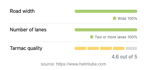
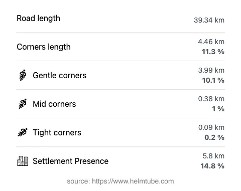
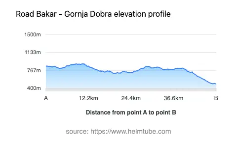
The Bakar–Lokvarsko Jezero–Gornja Dobra route covers approximately 39.3 km (24.4 miles) of asphalt surface, with the majority of the road classified as wide (about 94%). The surface quality is rated as very good, providing a comfortable and predictable riding experience. The road is predominantly two lanes (about 98%), supporting safe overtaking and steady traffic flow. Curvature is moderate, with the route offering gently curved sections rather than sharp or technical turns. Elevation ranges from 488 m (1,601 ft) to 902 m (2,959 ft), resulting in gradual climbs and descents. The maximum speed limit is 50 km/h (31 mph), which is typical for roads passing through mixed terrain and occasional inhabited areas (approximately 14.8% of the route). The road’s alignment along Lujzinska cesta ensures a blend of historical context and modern riding conditions.


Tourist Attractions and Points of Interest
One of the defining features of this route is its proximity to Lokvarsko jezero, a 1.7 km² (0.66 sq mi) artificial lake known for its clear waters and recreational opportunities. The road runs directly along the lake, offering multiple viewpoints for riders to pause and appreciate the landscape. In addition to the lake, several designated viewpoints are accessible from the road, providing panoramic vistas of the surrounding Gorski Kotar region. The area is also recognized for its forested hills and opportunities for outdoor activities such as hiking and fishing. The town of Bakar at the route’s western end is notable for its historic architecture and maritime heritage, while Gornja Dobra serves as a gateway to the quieter, rural interior.
Road Closures, Seasonal Considerations, and Regulations
The Bakar–Lokvarsko Jezero–Gornja Dobra route is generally open to motorcycles year-round. However, due to its elevation and inland location, winter conditions may occasionally lead to temporary closures or hazardous riding surfaces, particularly in the higher sections near Lokvarsko jezero. Riders are advised to check local traffic updates and weather forecasts before planning a trip, especially during the winter months. There are no regular event-related closures reported for this route. Standard Croatian traffic regulations apply, including adherence to posted speed limits and the use of appropriate safety gear.
Tolls, Fees, and Further Information
There are currently no tolls or entrance fees required to ride the Bakar–Lokvarsko Jezero–Gornja Dobra route. Riders should be aware that toll conditions may change in the future, and it is advisable to consult official resources for the most up-to-date information. For comprehensive details on road tolls and entrance fees in Croatia, refer to the HAK (Croatian Automobile Club) website.
Explore the Region: Roads Close By
Discover more amazing roads located near the route featured in this article. The list below highlights nearby routes that are perfect for extending your ride or planning your next adventure.
Ride the Best: Croatia’s Top Motorcycle Roads
These are the best motorbiking roads in Croatia. The list below shows links to articles about top-rated motorcycle routes in the country. Explore the most popular roads in Croatia and plan your next unforgettable motorbike adventure.