Exploring the Čabar 67: A Technical Ride Through Southern Slovenia
Locals know best!
If you travel this road often or live close by you will be given a chance to provide your valuable rating soon! Sign in and stay connected.Location and Route Overview
The Čabar 67 is situated in southern Slovenia, close to the border with Croatia. The road connects several small settlements, including Podplanina, Draga, Srednja vas pri Dragi, and Trava, and runs parallel to the Čabranka River for a portion of its length. The route is positioned within a rural landscape, characterized by forested hills and agricultural land. The nearest significant town is Čabar, located just over 5 km (3.1 miles) from both the starting and ending points of the road. An interactive map showing the precise route of the Čabar 67 can be found at the end of this article.
Road Characteristics and Riding Experience
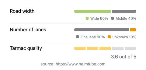
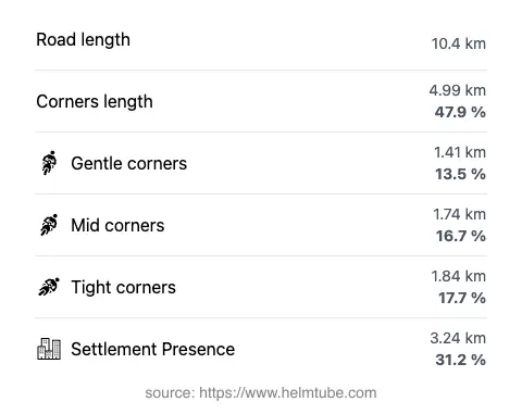
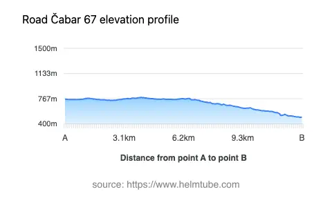
The Čabar 67 extends for approximately 10.4 km (6.5 miles), with an elevation range from 497 m (1,631 ft) to 785 m (2,575 ft). The road is predominantly asphalted, with a surface quality that can be described as average to good. Riders will encounter a very twisty alignment, making it suitable for those who appreciate technical riding without extreme hairpins. The width of the road varies, with about half of the route being wide and the remainder of medium width, while narrow sections are minimal. Most of the road is single-lane (about 90%), which requires attention when passing oncoming vehicles, especially in the more confined segments. Approximately one-third of the route passes through inhabited areas, providing occasional glimpses of rural Slovenian life. The Čabar 67 also runs adjacent to the Čabranka River for a short distance, adding to the route's geographical interest.
Local Attractions and Points of Interest
While the Čabar 67 itself is primarily a connector between small settlements, the surrounding region offers several attractions for those interested in extending their journey. The nearby town of Čabar, just across the border in Croatia, is known for its historical significance and proximity to the Kupa River. The area is also characterized by dense forests and opportunities for hiking and nature observation. Riders may wish to explore the rural charm of settlements like Podplanina and Draga, which provide a glimpse into traditional Slovenian countryside life. For those interested in cross-border travel, the Čabar 67 serves as a practical route towards the Croatian border, opening up further exploration opportunities in the Gorski Kotar region.
Road Closures, Seasonal Considerations, and Regulations
There are no permanent closures for motorcycles on the Čabar 67. However, as with many rural roads in Slovenia, temporary closures may occur due to maintenance work, adverse weather, or local events. The road is not subject to regular winter closure, but riders should be aware that conditions can become challenging during periods of heavy snowfall or ice, particularly at higher elevations. It is advisable to check local traffic updates before planning a ride, especially in the winter months. For up-to-date information on road conditions and closures, consult the official Slovenian Traffic Information Center.
Tolls, Fees, and Practical Information
The Čabar 67 does not currently require the payment of a toll or entrance fee for motorcycles. Riders should note that toll conditions may change in the future, and it is recommended to verify the latest information before traveling. For comprehensive details on road tolls and vignettes in Slovenia, refer to the official DARS vignette information page. Fuel stations and amenities are limited along the route, so it is advisable to refuel and stock up on essentials in larger towns before embarking on the journey.
Explore the Region: Roads Close By
Discover more amazing roads located near the route featured in this article. The list below highlights nearby routes that are perfect for extending your ride or planning your next adventure.
Ride the Best: Slovenia’s Top Motorcycle Roads
These are the best motorbiking roads in Slovenia. The list below shows links to articles about top-rated motorcycle routes in the country. Explore the most popular roads in Slovenia and plan your next unforgettable motorbike adventure.