Exploring the Čabranka Riverside Route: A Motorcyclist’s Guide to the Risnjak National Park Border Road
Locals know best!
If you travel this road often or live close by you will be given a chance to provide your valuable rating soon! Sign in and stay connected.Location and Overview of the Čabranka Riverside Route
Županijska cesta 5031, hereafter referred to as the Čabranka Riverside Route, is situated in the northwestern part of Croatia, close to the Slovenian border. The road runs parallel to the Čabranka River for nearly its entire length, with the town of Čabar serving as both the nearest settlement to the starting and ending points. The route skirts the boundary of Nacionalni park Risnjak, a protected area known for its diverse flora and fauna. This location places the road in a region characterized by forested hills, river valleys, and proximity to the Gorski Kotar highlands. An interactive map showing the precise alignment of the road can be found at the end of this article.
Road Characteristics and Riding Experience
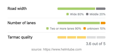
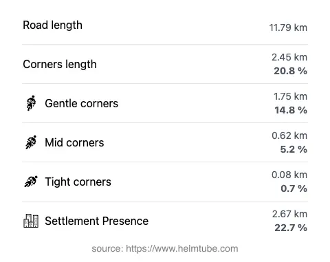
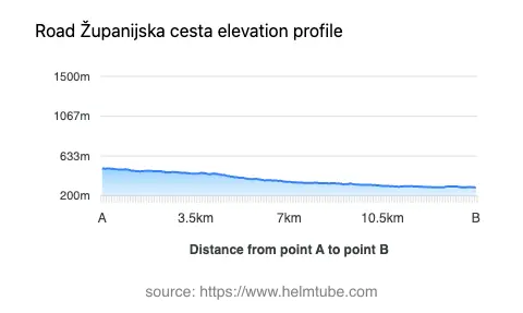
The Čabranka Riverside Route extends for approximately 11.8 km (7.3 miles), with the majority of its length featuring two lanes (about 93%) and a wide carriageway (about 76%). The road surface is asphalt, with a quality rating that can be described as moderate—neither poor nor excellent, but generally reliable for motorcycle travel. The route is gently curved, offering a relaxed riding experience rather than a highly technical one. Elevation ranges from 292 m (958 ft) at its lowest point to 498 m (1,634 ft) at its highest, resulting in mild elevation changes suitable for most riders. The maximum speed limits along the road are 40 km/h (25 mph) and 20 km/h (12 mph) in certain sections, reflecting the road’s proximity to inhabited areas and the national park boundary. Approximately 22.7% of the route passes through inhabited zones, while the remainder traverses sparsely populated or natural landscapes.
Natural Features and Points of Interest
The defining natural feature of this route is its close alignment with the Čabranka River, a tributary of the Kupa River. For nearly 98% of its length, the road runs adjacent to the river, providing continuous views of the waterway and the surrounding riparian environment. The proximity to Nacionalni park Risnjak adds ecological significance, as the park is home to lynx, bears, and a variety of bird species. The town of Čabar serves as a convenient base for exploring the region, offering basic amenities and access to local cultural sites. Riders interested in extending their journey can explore the broader Gorski Kotar area, known for its forests and outdoor activities.
Access, Closures, and Regulations
There are currently no known restrictions on motorcycle access along the Čabranka Riverside Route. The road is open year-round, but riders should be aware that winter conditions in the Gorski Kotar region can lead to temporary closures or hazardous surfaces due to snow and ice. No regular event-related closures have been reported. It is advisable to check local traffic updates or consult the Nacionalni park Risnjak website for any temporary restrictions, especially during periods of adverse weather or park maintenance activities.
Tolls, Fees, and Further Information
There is no toll or entrance fee required to ride the Čabranka Riverside Route itself. However, entry into Nacionalni park Risnjak may be subject to a fee if you plan to visit the park’s interior or use its facilities. Toll and fee conditions may change in the future, so it is recommended to verify the latest information on the HAK (Croatian Automobile Club) website, which provides up-to-date details on road tolls and entrance fees across Croatia.
Explore the Region: Roads Close By
Discover more amazing roads located near the route featured in this article. The list below highlights nearby routes that are perfect for extending your ride or planning your next adventure.
Ride the Best: Croatia’s Top Motorcycle Roads
These are the best motorbiking roads in Croatia. The list below shows links to articles about top-rated motorcycle routes in the country. Explore the most popular roads in Croatia and plan your next unforgettable motorbike adventure.