Exploring the Čepovan–Tolmin Route: A Motorcyclist’s Guide
Locals know best!
If you travel this road often or live close by you will be given a chance to provide your valuable rating soon! Sign in and stay connected.Location and Overview
The Čepovan–Tolmin road is situated in the western part of Slovenia, running between the village of Čepovan and the town of Tolmin. The route traverses the Čepovanski dol valley and skirts the edge of the Julian Alps, providing a transition from rural uplands to the Soča River basin. The road passes through several small settlements, including Postaja and Grudnica, and is characterized by its proximity to the Idrijca River for a portion of its length. An interactive map showing the road can be found at the end of the article.
Road Characteristics and Riding Experience
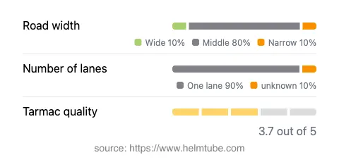
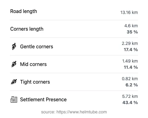
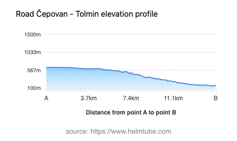
The Čepovan–Tolmin route covers approximately 13.2 km (8.2 miles), with an elevation range from 163 m (535 ft) to 645 m (2,116 ft). The road surface is asphalt, with a quality rating that can be described as generally good, though not excellent. Riders will encounter a mix of gently curved and moderately twisty sections, making it suitable for those who appreciate a varied but not overly demanding ride. The majority of the road is of medium width (about 70%), with narrower stretches (10%) and some wider segments (12%). Most of the route is single-lane (about 88%), with only a small portion offering two lanes. Approximately 43% of the road passes through inhabited areas, providing occasional opportunities for stops in local villages.
Natural Features and Points of Interest
This road is notable for its passage through the Čepovanski dol valley, a lesser-known but picturesque area that offers views of forested slopes and rural landscapes. For about 15% of its length, the route runs adjacent to the Idrijca River, a tributary of the Soča (Isonzo) River, known for its clear waters and fishing opportunities. The proximity to the Julian Alps adds to the appeal, as the road skirts the southern edge of this mountain range. Riders may also consider a stop in Tolmin, a town recognized for its access to the Tolmin Gorge and as a gateway to the Soča Valley.
Road Closures, Tolls, and Practical Information
The Čepovan–Tolmin road is generally open to motorcycles year-round, with no regular seasonal closures reported. However, temporary closures may occur due to maintenance or local events, particularly during periods of heavy rainfall or adverse weather, as is common in mountainous regions. There are currently no tolls or entrance fees required to use this road, but toll conditions may change in the future. For the most up-to-date information on road tolls and entrance fees in Slovenia, riders should consult the official DARS website.
Planning Your Ride
When planning a ride along the Čepovan–Tolmin route, motorcyclists should be prepared for variable road widths and occasional narrow sections, especially in the valley. The road’s moderate curviness makes it accessible to a wide range of riders, though caution is advised in inhabited areas and during wet conditions. The elevation changes are gradual, and the surrounding landscape offers a sense of remoteness without being isolated. Facilities are limited along the route, so it is advisable to refuel and stock up on essentials in Čepovan or Tolmin before setting out. For those interested in exploring further, Tolmin provides access to the Soča Valley and the Tolmin Gorge, both popular destinations for outdoor activities and sightseeing.
Explore the Region: Roads Close By
Discover more amazing roads located near the route featured in this article. The list below highlights nearby routes that are perfect for extending your ride or planning your next adventure.
Ride the Best: Slovenia’s Top Motorcycle Roads
These are the best motorbiking roads in Slovenia. The list below shows links to articles about top-rated motorcycle routes in the country. Explore the most popular roads in Slovenia and plan your next unforgettable motorbike adventure.