Exploring the Cerknica–Bloke Valley Route: A Motorcyclist’s Guide
Locals know best!
If you travel this road often or live close by you will be given a chance to provide your valuable rating soon! Sign in and stay connected.Location and Geographic Context
The Cerknica–Bloke Valley Route is situated in southern Slovenia, within the Inner Carniola region. The road runs near the town of Cerknica, a settlement known for its proximity to the intermittent Lake Cerknica. The route follows the Cerkniščica River for a significant portion and traverses the Bloke Valley, an area recognized for its rolling landscapes and historical significance. The region is less frequented by international tourists, offering a quieter alternative to Slovenia’s more prominent alpine passes. An interactive map showing the road can be found at the end of the article.
Road Characteristics and Riding Experience
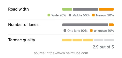
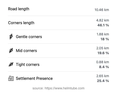
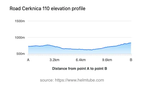
The Cerknica–Bloke Valley Route extends for approximately 10.5 km (6.5 miles), with elevations ranging from 620 m (2,034 ft) to 835 m (2,740 ft). The road is predominantly surfaced with asphalt, though the quality is moderate, rated as fair to average. Riders will encounter a mix of gently curved and moderately twisty sections, making it suitable for those seeking a technical but not overly demanding ride. The road is mostly single-lane (about 90%), with the majority of its width classified as middle, and some stretches being narrow or wide. About a quarter of the route passes through inhabited areas, while the remainder traverses open countryside, riverbanks, and valley landscapes. The proximity to the Cerkniščica River (31% of the route) and the passage through the Bloke Valley (13%) add to the route’s natural appeal.
Points of Interest Along the Route
While the route itself is primarily rural, its endpoints and surroundings offer several attractions. The town of Cerknica is notable for its access to Lake Cerknica, one of Europe’s largest intermittent lakes, which is a unique hydrological phenomenon. The Bloke Valley is historically significant as the birthplace of Slovenian skiing and offers opportunities for hiking and nature observation. The Cerkniščica River, which accompanies the road for a substantial distance, is a lesser-known waterway that contributes to the area’s biodiversity. Riders interested in local culture may also explore traditional villages and rural landscapes characteristic of Inner Carniola.
Road Closures, Seasonal Considerations, and Regulations
There are no permanent closures for motorcycles on the Cerknica–Bloke Valley Route. However, as with many rural roads in Slovenia, temporary closures may occur due to maintenance, weather conditions, or local events. The road is not typically subject to winter closure, but riders should be aware that snow and ice can affect surface conditions during colder months, especially at higher elevations. It is advisable to check local traffic updates before planning a ride, particularly in late autumn and early spring.
Tolls, Fees, and Practical Information
The Cerknica–Bloke Valley Route does not currently require a toll or entrance fee for motorcycles. Riders should note that toll conditions may change in the future, and it is recommended to consult the official DARS website for up-to-date information on road tolls and vignettes in Slovenia. Fuel stations and amenities are limited along the route, so planning ahead is advisable. The road’s moderate surface quality and variable width require attentive riding, particularly in wet or low-visibility conditions.
Explore the Region: Roads Close By
Discover more amazing roads located near the route featured in this article. The list below highlights nearby routes that are perfect for extending your ride or planning your next adventure.
Ride the Best: Slovenia’s Top Motorcycle Roads
These are the best motorbiking roads in Slovenia. The list below shows links to articles about top-rated motorcycle routes in the country. Explore the most popular roads in Slovenia and plan your next unforgettable motorbike adventure.