Exploring the Cesta Domovinskog Rata Route: A Motorcyclist’s Guide
Locals know best!
If you travel this road often or live close by you will be given a chance to provide your valuable rating soon! Sign in and stay connected.Location and Overview of the Cesta Domovinskog Rata
The Županijska cesta 6112, more commonly referred to as the Cesta Domovinskog rata, is situated in the Split-Dalmatia County of Croatia. The road serves as a regional connector between the villages of Prgomet and Kladnjice, traversing a landscape typical of the Dalmatian hinterland. The route lies inland from the Adriatic coast, offering a quieter alternative to the busier coastal highways. The area is characterized by rolling hills and rural settlements, with the road providing access to local communities and agricultural areas. An interactive map showing the precise route of the Cesta Domovinskog rata can be found at the end of this article.
Road Characteristics and Riding Experience
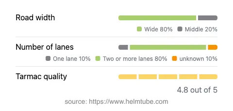
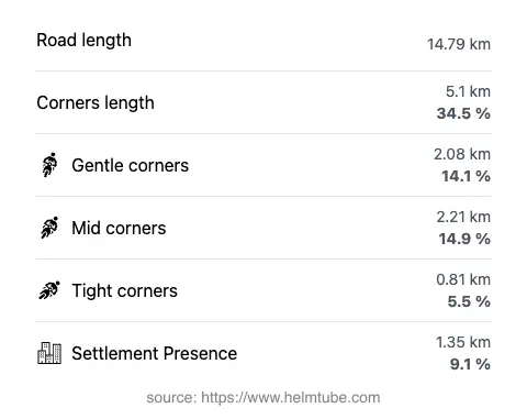
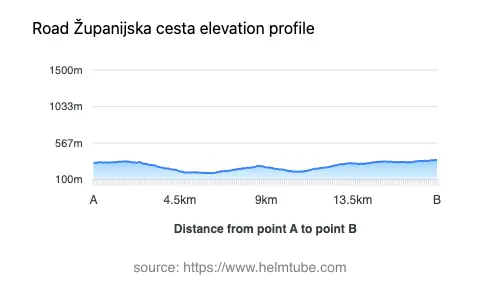
The Cesta Domovinskog rata extends for approximately 14.8 km (9.2 miles), with elevations ranging from 184 m (604 ft) to 353 m (1,158 ft). The road is predominantly wide (about 79%), with the remainder being of medium width. The surface is asphalt and is generally rated as excellent, providing a smooth and predictable riding experience. The route is moderately curvy, offering a mix of gentle bends and straight sections, making it suitable for riders seeking a relaxed journey rather than technical challenges. Two lanes are present for most of the route (about 83%), ensuring comfortable passing opportunities. The road passes through inhabited areas for a small portion (approximately 9.1%), with the majority of the ride taking place in open countryside.
Points of Interest and Local Attractions
While the Cesta Domovinskog rata itself is primarily a functional regional road, its proximity to the Dalmatian hinterland offers access to several points of interest. The nearby village of Prgomet is known for its traditional stone architecture and rural ambiance. Kladnjice, at the other end of the route, provides a gateway to the natural landscapes of inland Dalmatia. Riders interested in exploring further can visit the Klis Fortress, a historic site located within a reasonable riding distance, or the city of Split for a broader cultural experience. The region is also known for its vineyards and olive groves, which can be observed along the route.
Practical Information: Closures, Tolls, and Regulations
The Cesta Domovinskog rata is open to motorcycles year-round, with no regular seasonal closures reported. Temporary closures may occur due to roadworks or local events, but these are infrequent and typically well-signposted. There are currently no tolls or entrance fees required to use this road. Riders should be aware that toll conditions may change in the future; for the most up-to-date information on road tolls and fees in Croatia, consult the HAK road tolls page. The maximum speed limit on this route is 50 km/h (31 mph) in inhabited areas and 40 km/h (25 mph) in certain sections, as indicated by local signage. Riders are advised to adhere to posted speed limits and exercise caution, especially in rural areas where agricultural vehicles may be present.
Summary and Map
The Cesta Domovinskog rata (Županijska cesta 6112) offers a reliable and well-maintained route for motorcyclists traveling through the Split-Dalmatia region. With its excellent surface quality, moderate curves, and access to local attractions, it is a practical choice for those seeking to explore the Dalmatian hinterland. For an interactive map of the route, please refer to the geospatial markup provided below.
Explore the Region: Roads Close By
Discover more amazing roads located near the route featured in this article. The list below highlights nearby routes that are perfect for extending your ride or planning your next adventure.
Ride the Best: Croatia’s Top Motorcycle Roads
These are the best motorbiking roads in Croatia. The list below shows links to articles about top-rated motorcycle routes in the country. Explore the most popular roads in Croatia and plan your next unforgettable motorbike adventure.