Exploring the D219: A Motorcyclist’s Guide to the Sinj Hinterland Route
Locals know best!
If you travel this road often or live close by you will be given a chance to provide your valuable rating soon! Sign in and stay connected.Location and Overview of the D219
The D219 is situated in southern Croatia, traversing the inland region north of Split. The road primarily serves as a connector between the town of Sinj and several smaller settlements, including Put Odrine, Put Pavića, and Vrlička ulica. Sinj, the nearest major town, is known for its historical significance and the annual Sinj Alka tournament, a UNESCO-listed equestrian competition. The D219 begins near Sinj and heads northeast, passing through a mix of inhabited and rural landscapes. An interactive map showing the precise route of the D219 can be found at the end of this article.
Road Characteristics and Riding Experience
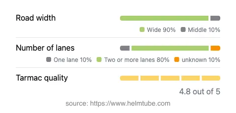
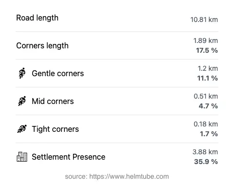
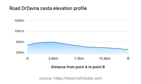
The D219 extends for approximately 10.8 km (6.7 miles), offering a predominantly straight and gently curved ride. The road is surfaced with high-quality asphalt, rated as excellent, which ensures a comfortable journey for motorcyclists. The majority of the route features wide lanes (about 85%), with the remainder consisting of middle and narrow sections. Two-lane traffic is present along most of the road (about 83%), while single-lane segments are minimal. The elevation ranges from 326 m (1,070 ft) to 623 m (2,044 ft), providing mild altitude changes without steep climbs or descents. The maximum speed limit is 50 km/h (31 mph), reflecting the road’s passage through both inhabited and open areas. Approximately 36% of the route passes through settlements, offering occasional opportunities to stop and explore local communities.
Local Attractions and Points of Interest
While the D219 itself is not renowned for dramatic curves or mountain vistas, it serves as a gateway to several attractions in the Sinj region. The town of Sinj is a highlight, famous for its historic fortress and the Sinj Alka event. Riders can also explore the Cetina River valley, known for its natural beauty and outdoor activities. The rural settlements along the D219, such as Put Odrine and Put Pavića, offer a glimpse into traditional Dalmatian life. For those interested in local culture, Sinj’s museums and churches provide additional points of interest.
Road Closures, Seasonal Access, and Regulations
The D219 is a public road open to all vehicles, including motorcycles, throughout the year. There are no regular seasonal closures, and the route remains accessible during winter, although riders should be aware of occasional weather-related disruptions typical of inland Dalmatia. No event-related closures have been reported for this section of the D219. It is advisable to check local traffic updates before planning a ride, especially during periods of adverse weather.
Tolls, Fees, and Additional Information
There are currently no tolls or entrance fees required to ride the D219. The road is part of Croatia’s state road network, which is generally toll-free except for certain highways and tunnels. Riders should note that toll conditions may change in the future. For the most up-to-date information on road tolls and fees in Croatia, consult the official Hrvatske autoceste website. Always verify current regulations before your journey.
Interactive Map and Route Planning
For those interested in planning their ride, an interactive map of the D219 is available at the end of this article. This resource provides detailed information on the route, nearby attractions, and potential stops along the way, assisting motorcyclists in making the most of their journey through the Sinj hinterland.
Explore the Region: Roads Close By
Discover more amazing roads located near the route featured in this article. The list below highlights nearby routes that are perfect for extending your ride or planning your next adventure.
Ride the Best: Croatia’s Top Motorcycle Roads
These are the best motorbiking roads in Croatia. The list below shows links to articles about top-rated motorcycle routes in the country. Explore the most popular roads in Croatia and plan your next unforgettable motorbike adventure.