Exploring Državna cesta D117: The Island Artery of Vis
Locals know best!
If you travel this road often or live close by you will be given a chance to provide your valuable rating soon! Sign in and stay connected.Location and Geographic Context
Državna cesta D117 is situated entirely on the island of Vis, one of Croatia’s most westerly inhabited islands in the Adriatic Sea. The road serves as the main artery for the island, connecting the town of Komiža with other settlements and providing access to the coastline of Zaljev Komiža bay. The route’s proximity to the sea and its passage through inhabited areas make it a vital link for both residents and visitors. An interactive map showing the route of Državna cesta D117 can be found at the end of this article.

Road Characteristics and Riding Experience
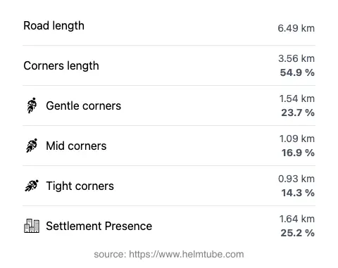
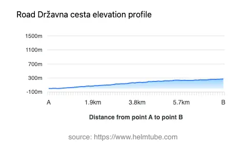
The D117 road extends for approximately 6.5 km (4 miles), running from the outskirts of Komiža and following the contours of the island’s terrain. The road is moderately twisty, with a layout that provides a balance between gently curved and more pronounced bends, making it suitable for riders seeking a varied but manageable riding experience. The surface is asphalt and generally rated as good, offering a comfortable ride for most motorcycles. The road is predominantly wide (about 78%), with some sections of medium and narrow width, and features two lanes for the majority of its length (about 86%). Elevation ranges from near sea level at 1 m (3 ft) to a maximum of 270 m (886 ft), offering occasional views over the bay and the surrounding landscape. Speed limits vary along the route, with posted limits of 20, 30, and 40 km/h (12, 19, and 25 mph), reflecting the road’s curves and proximity to inhabited areas.
Settlements and Points of Interest
The D117 passes through or near several settlements, including Put Benediktinaca, Obala pape Aleksandra III., and Težačka cesta, with Komiža serving as both the starting and ending point for many journeys. Komiža is a historic town known for its fishing heritage and picturesque harbor. Along the route, riders will encounter a notable viewpoint, offering an opportunity to pause and take in the panoramic vistas of Zaljev Komiža bay. The road’s alignment along the coastline for approximately 43% of its length provides frequent glimpses of the Adriatic and access to local beaches and coves. For those interested in exploring further, Vis island itself is rich in history, with sites such as the town of Vis and remnants of military fortifications from various periods.
Road Access, Closures, and Practical Information
Državna cesta D117 is open to motorcycles year-round, with no regular seasonal closures reported. However, as with many island roads, weather conditions such as heavy rain or strong winds may occasionally impact travel, particularly during the winter months. There are no known event-related closures affecting this route. Riders are advised to check local sources for any temporary restrictions before setting out.
Tolls, Fees, and Additional Resources
There is currently no toll or entrance fee required to use Državna cesta D117. However, toll conditions may change in the future, and it is recommended to consult official resources for the most up-to-date information. For details on road tolls and entrance fees in Croatia, visit the Croatian Automobile Club (HAK) website. Motorcyclists should also be aware of local traffic regulations and ensure their vehicles are compliant with Croatian road safety standards.
Explore the Region: Roads Close By
Discover more amazing roads located near the route featured in this article. The list below highlights nearby routes that are perfect for extending your ride or planning your next adventure.
Ride the Best: Croatia’s Top Motorcycle Roads
These are the best motorbiking roads in Croatia. The list below shows links to articles about top-rated motorcycle routes in the country. Explore the most popular roads in Croatia and plan your next unforgettable motorbike adventure.