Exploring Državna cesta D60: A Technical Overview for Motorcyclists
Locals know best!
If you travel this road often or live close by you will be given a chance to provide your valuable rating soon! Sign in and stay connected.Location and Access
Državna cesta D60 is situated in southern Croatia, within the Dalmatian hinterland. The road primarily connects the settlements of Glavina Donja and Most Vrljika, with the town of Imotski located just over 1 km (0.6 miles) from its starting point. The route traverses a region characterized by karst landscapes and agricultural areas, providing access to local communities and serving as a connector between inland and coastal routes. An interactive map showing the precise route of Državna cesta D60 can be found at the end of this article.
Road Characteristics and Technical Details
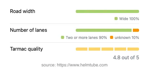
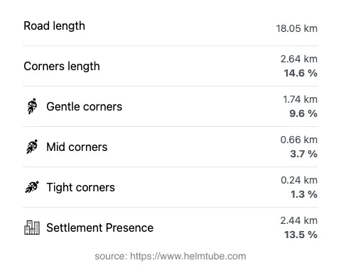
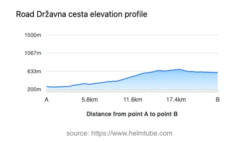
Državna cesta D60 extends for approximately 18.1 km (11.3 miles), with the majority of its length classified as wide and featuring two lanes (about 95%). The road surface is asphalt and is rated as excellent, offering a smooth and predictable riding experience. The route is not particularly twisty, with gentle curves dominating the alignment, making it suitable for riders seeking a relaxed journey rather than a challenging ride. Elevation along the road ranges from 259 m (850 ft) to 679 m (2,228 ft), providing moderate altitude changes without steep gradients. The maximum speed limits vary along the route, with posted limits of 30, 40, 50, 60, 70, and 90 km/h (19, 25, 31, 37, 43, and 56 mph) depending on the specific section and proximity to inhabited areas. Approximately 13.5% of the road passes through populated zones, while the remainder traverses open countryside.
Natural Features and Points of Interest
One of the notable features of Državna cesta D60 is its adjacency to the Vrljika river for about 10% of its length. The Vrljika is a unique karst river known for its ecological significance and distinctive hydrological characteristics. While the road itself does not pass directly through major tourist attractions, its proximity to Imotski provides access to the famous Blue Lake and Red Lake, both of which are natural sinkhole lakes and popular destinations for visitors to the region. These sites offer opportunities for sightseeing and short detours for those interested in geological phenomena.
Road Closures, Seasonal Considerations, and Regulations
Državna cesta D60 is a public state road and is generally open to all vehicles, including motorcycles, throughout the year. There are no regular seasonal closures, and the road remains accessible during winter months, although weather conditions may occasionally impact travel. Temporary closures may occur due to maintenance work or local events, but these are typically announced in advance by Croatian road authorities. Riders are advised to check for current road conditions and any potential restrictions before planning their journey.
Tolls, Fees, and Additional Information
There are currently no tolls or entrance fees required to use Državna cesta D60. The road is part of the national road network and is maintained by the Croatian authorities. However, toll conditions may change in the future, and riders should consult official resources for the most up-to-date information. For details on road tolls and fees in Croatia, visit the Hrvatske autoceste website.
Explore the Region: Roads Close By
Discover more amazing roads located near the route featured in this article. The list below highlights nearby routes that are perfect for extending your ride or planning your next adventure.
Ride the Best: Croatia’s Top Motorcycle Roads
These are the best motorbiking roads in Croatia. The list below shows links to articles about top-rated motorcycle routes in the country. Explore the most popular roads in Croatia and plan your next unforgettable motorbike adventure.