Exploring the Godovič – Dolenja Trebuša Route: A Technical Ride Through Western Slovenia
Locals know best!
If you travel this road often or live close by you will be given a chance to provide your valuable rating soon! Sign in and stay connected.Location and Overview of the Godovič – Dolenja Trebuša Road
The Godovič – Dolenja Trebuša road is situated in western Slovenia, connecting the settlements of Godovič and Dolenja Trebuša. The route traverses a region characterized by rolling hills, forested areas, and the presence of the Idrijca River, which accompanies the road for a significant portion of its length. The nearest major town to the starting point is Idrija, located approximately 6.9 km (4.3 miles) from Godovič. This area is recognized for its natural beauty and historical significance, particularly due to Idrija’s UNESCO-listed mercury mine. An interactive map showing the precise route of the Godovič – Dolenja Trebuša road can be found at the end of this article.
Road Characteristics and Riding Experience
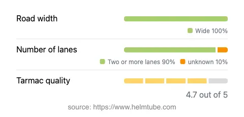
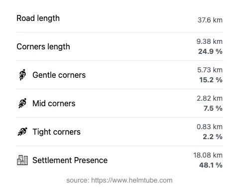
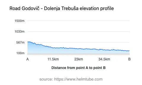
The Godovič – Dolenja Trebuša route extends for approximately 37.6 km (23.4 miles), offering a ride that is gently curved for most of its length. The road surface is asphalt and is generally rated as excellent, providing a smooth and predictable riding experience. The majority of the route consists of two lanes (about 95%), with a wide road width for most of the journey (about 96%), ensuring comfortable passage for both motorcycles and other vehicles. Only a very small portion is single-lane or of medium width, minimizing the need for cautious overtaking or tight maneuvering. The elevation ranges from 197 m (646 ft) to 591 m (1,939 ft), with gradual ascents and descents rather than steep climbs. The route passes through a mix of inhabited areas (about 48%), offering occasional opportunities for rest stops and refreshments.
Riding Along the Idrijca River
A defining feature of this road is its alignment with the Idrijca River, which runs adjacent to the route for approximately 77% of its length. The river is a tributary of the Soča (Isonzo) and is known for its clear waters and natural surroundings. Riders will find the proximity to the river enhances the overall experience, with frequent views of the water and the surrounding valley. The river’s presence also contributes to the local microclimate, which can be cooler and more humid, especially in the early morning or late afternoon.
Speed Limits, Safety, and Seasonal Considerations
The Godovič – Dolenja Trebuša road is subject to varying speed limits, typically set at 50 km/h (31 mph), 70 km/h (43 mph), and 90 km/h (56 mph) depending on the specific section and proximity to settlements. The road’s excellent surface quality and wide lanes support safe riding at these speeds, but riders should remain attentive to local traffic regulations and potential changes in road conditions, particularly in inhabited areas. There are no known permanent closures for motorcycles, and the road generally remains open year-round. However, temporary closures may occur due to maintenance or weather-related events, especially during periods of heavy rain or snow. It is advisable to check local traffic updates before planning a ride.
Tolls, Fees, and Further Information
Currently, there are no tolls or entrance fees required to use the Godovič – Dolenja Trebuša road. Riders should be aware that toll conditions may change in the future, and it is recommended to consult the official DARS website for the most up-to-date information on road tolls and fees in Slovenia. The absence of tolls makes this route accessible for both local and visiting motorcyclists, contributing to its popularity as a regional thoroughfare.
Explore the Region: Roads Close By
Discover more amazing roads located near the route featured in this article. The list below highlights nearby routes that are perfect for extending your ride or planning your next adventure.
Ride the Best: Slovenia’s Top Motorcycle Roads
These are the best motorbiking roads in Slovenia. The list below shows links to articles about top-rated motorcycle routes in the country. Explore the most popular roads in Slovenia and plan your next unforgettable motorbike adventure.