Exploring the Griče–Karlovac Road: A Technical Overview for Motorcyclists
Locals know best!
If you travel this road often or live close by you will be given a chance to provide your valuable rating soon! Sign in and stay connected.Location and Route Overview
The Griče–Karlovac road is situated in central Croatia, connecting the small village of Borlin and the urban center of Karlovac. The route begins in the rural surroundings of Griče and proceeds northeast, passing through Borlin before reaching Karlovac, a city known for its historical significance and river confluences. The road serves as a local connector, facilitating access between residential areas and the city. An interactive map showing the precise route can be found at the end of this article.
Road Characteristics and Riding Experience
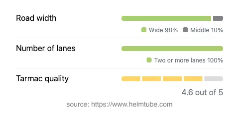
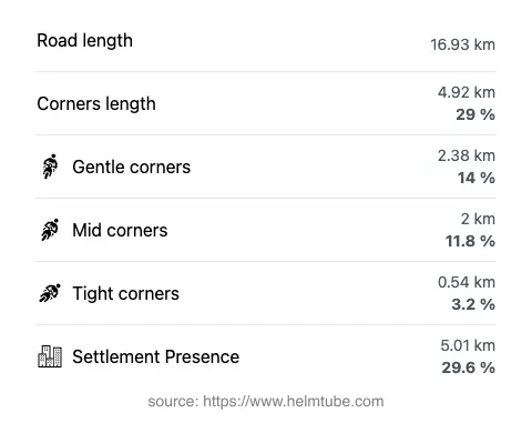
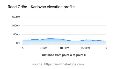
The Griče–Karlovac road extends for approximately 16.9 km (10.5 miles), with the majority of its length featuring wide, two-lane sections (about 98%). The road is predominantly asphalted and is rated as having very good surface quality, providing a comfortable ride for most motorcycles. Riders will encounter a moderately curvy alignment, offering a balance between straight stretches and gently curved segments. The elevation ranges from 118 m (387 ft) at its lowest point to 264 m (866 ft) at its highest, resulting in mild elevation changes suitable for riders of all experience levels. The route passes through inhabited areas for roughly 30% of its length, with the remainder traversing open countryside and forested patches.
Speed Limits, Traffic, and Safety Considerations
Speed limits along the Griče–Karlovac road vary, with posted limits of 70 km/h (43 mph), 50 km/h (31 mph), and 40 km/h (25 mph) depending on the proximity to settlements and road conditions. The road’s width is predominantly wide (about 88%), allowing for safe overtaking and comfortable maneuvering, while narrower sections are minimal. Traffic volumes are generally moderate, with increased activity near Karlovac, especially during peak commuting hours. Riders should remain attentive to local traffic regulations and be cautious in inhabited zones, where pedestrian and local vehicle activity may be higher.
Road Closures, Seasonal Access, and Toll Information
There are currently no known restrictions or closures for motorcycles on the Griče–Karlovac road. The route remains accessible throughout the year, with no regular seasonal closures reported. However, riders should be aware that weather conditions, particularly during winter months, may affect surface traction and visibility. There are no tolls or entrance fees required to use this road, but toll conditions may change in the future. For the most up-to-date information on road tolls and entrance fees in Croatia, consult the official Hrvatske autoceste website.
Nearby Attractions and Points of Interest
While the Griče–Karlovac road itself is primarily a local connector, the city of Karlovac offers several attractions for visiting motorcyclists. Notable sites include the Karlovac City Museum, the historic Dubovac Castle, and the confluence of four rivers, which is a defining feature of the city’s landscape. Riders interested in exploring the region further may also consider visiting the Aquatika Freshwater Aquarium. These attractions provide opportunities for cultural enrichment and relaxation after a day’s ride.
Explore the Region: Roads Close By
Discover more amazing roads located near the route featured in this article. The list below highlights nearby routes that are perfect for extending your ride or planning your next adventure.
Ride the Best: Croatia’s Top Motorcycle Roads
These are the best motorbiking roads in Croatia. The list below shows links to articles about top-rated motorcycle routes in the country. Explore the most popular roads in Croatia and plan your next unforgettable motorbike adventure.