Exploring the Idrija–Žiri Road: A Technical Overview for Motorcyclists
Locals know best!
If you travel this road often or live close by you will be given a chance to provide your valuable rating soon! Sign in and stay connected.Location and Route Overview
The Idrija–Žiri road is situated in western Slovenia, linking the towns of Idrija and Žiri. The route traverses the hilly terrain between these settlements, passing through smaller villages such as Žirovska cesta, Idrijska cesta, Govejk, Mokraška vas, and Ledinsko Razpotje. The road lies within the traditional region of Inner Carniola, an area known for its karst landscapes and historical mining heritage. An interactive map showing the precise route can be found at the end of this article.
Road Characteristics and Riding Experience
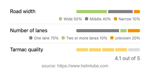
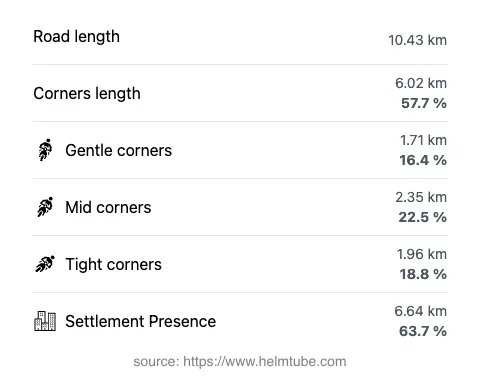
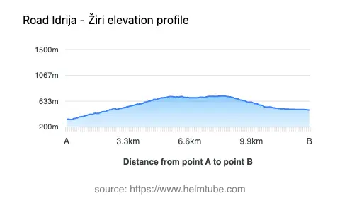
The Idrija–Žiri road extends for approximately 10.4 km (6.5 miles), offering a moderately twisty ride that will appeal to riders who enjoy a mix of gentle and sharper curves. The road surface is asphalt and is generally of good quality, with most sections rated as smooth and well-maintained. Riders will encounter a combination of road widths: nearly half of the route is wide (about 47%), while the remainder alternates between middle and narrow sections. The majority of the road is single-lane, with some stretches accommodating two lanes, particularly near settlements. Elevation ranges from 326 m (1,070 ft) at its lowest point to 722 m (2,369 ft) at its highest, providing moderate altitude changes without extreme gradients. The maximum speed limits are set at 50 km/h (31 mph) in inhabited areas and up to 90 km/h (56 mph) in open stretches, reflecting the road’s variable character and proximity to residential zones.
Natural Features and Points of Interest
While the road is primarily functional, it does offer brief proximity to the Idrijca River, a tributary of the Soča (Isonzo) River, for about 10% of its length. The surrounding landscape is characterized by rolling hills, forested slopes, and occasional open vistas. Idrija, at the eastern end of the route, is recognized for its UNESCO-listed mercury mine and lace-making tradition, while Žiri is known for its shoemaking history. Both towns provide opportunities for cultural exploration and rest stops. The settlements along the route, such as Govejk and Mokraška vas, offer glimpses into rural Slovenian life, though services are limited outside the main towns.
Seasonal Accessibility and Road Regulations
The Idrija–Žiri road remains open to motorcycles throughout the year, with no specific seasonal closures reported. However, winter conditions in the region can lead to temporary restrictions or hazardous riding surfaces due to snow and ice, particularly in higher sections. Riders are advised to check local weather forecasts and road maintenance updates before planning a winter journey. There are no known event-related closures affecting this route on a regular basis.
Tolls, Fees, and Practical Information
Currently, there are no tolls or entrance fees required for motorcycles on the Idrija–Žiri road. Riders should note that toll conditions may change in the future, and it is advisable to consult official resources for the most up-to-date information. For comprehensive details on road tolls and vignettes in Slovenia, refer to the official DARS website. Fuel stations and amenities are available in Idrija and Žiri, but are sparse along the route itself, so planning ahead is recommended.
Explore the Region: Roads Close By
Discover more amazing roads located near the route featured in this article. The list below highlights nearby routes that are perfect for extending your ride or planning your next adventure.
Ride the Best: Slovenia’s Top Motorcycle Roads
These are the best motorbiking roads in Slovenia. The list below shows links to articles about top-rated motorcycle routes in the country. Explore the most popular roads in Slovenia and plan your next unforgettable motorbike adventure.