Exploring Lokalna cesta 67185: A Technical Overview for Motorcyclists in Croatia
Locals know best!
If you travel this road often or live close by you will be given a chance to provide your valuable rating soon! Sign in and stay connected.Location and Geographic Context
Lokalna cesta 67185 is situated in Croatia, within the Dalmatian hinterland, east of the city of Split. The road lies in the Split-Dalmatia County, running through a rural area characterized by rolling hills and sparse settlements. The route is positioned between the coordinates 43.3186317°N, 17.240001°E and 43.3329318°N, 17.298278°E, traversing a landscape that is typical of the region's inland terrain. While the road does not pass directly through any major settlements, it is accessible from nearby villages and serves as a connector within the local road network. An interactive map showing the precise route of Lokalna cesta 67185 can be found at the end of this article.
Road Characteristics and Riding Experience
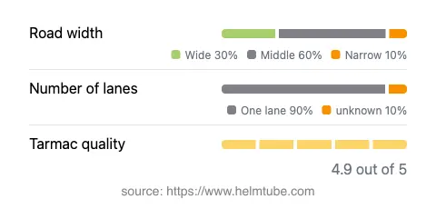
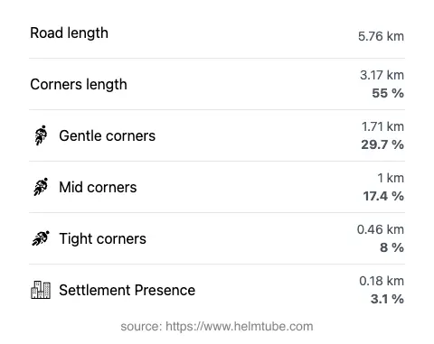
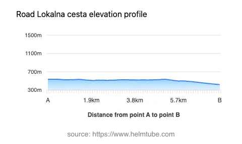
Lokalna cesta 67185 extends for approximately 5.8 km (3.6 miles), with an elevation range from 424 m (1,391 ft) to 539 m (1,768 ft). The road is surfaced with asphalt of high quality, rated as excellent by local standards. Riders will encounter a moderately curvy alignment, offering a balance between straight sections and gently winding segments. The majority of the road features a middle-width carriageway (about 58%), with additional stretches that are wide (25%) and a smaller portion that is narrow (8%). Most of the route consists of a single lane (about 86%), which is typical for local roads in this region. Only a small fraction of the road (3.1%) passes through inhabited areas, making it a quiet option for those seeking a less trafficked environment. The combination of moderate curves and excellent surface quality makes this road suitable for riders looking for a relaxed yet engaging ride.
Local Attractions and Points of Interest
While Lokalna cesta 67185 itself does not directly connect to major tourist attractions, its location in the Dalmatian hinterland places it within reach of several noteworthy sites. The nearby city of Imotski is known for its historic architecture and the famous Blue Lake and Red Lake, both of which are unique karst phenomena. Riders interested in exploring the cultural and natural heritage of the region may consider extending their journey to these destinations. The road also provides access to the broader network of rural routes in Split-Dalmatia County, which are valued for their tranquility and authentic local character.
Seasonal Accessibility and Road Closures
Lokalna cesta 67185 is generally open to motorcyclists throughout the year. There are no official restrictions on motorcycle access, and the road is not subject to regular seasonal closures. However, as with many rural roads in Croatia, temporary closures may occur due to maintenance work or adverse weather conditions, particularly during periods of heavy rain or occasional winter snowfall. Riders are advised to check local traffic updates before planning their trip. No event-related closures have been reported for this route.
Tolls, Fees, and Practical Information
There are currently no tolls or entrance fees required to use Lokalna cesta 67185. The road is part of the public local road network and is free of charge for all vehicles, including motorcycles. Riders should be aware that toll conditions may change in the future, and it is advisable to consult official sources for the most up-to-date information. For comprehensive details on road tolls and fees in Croatia, visit the Hrvatske autoceste website.
Explore the Region: Roads Close By
Discover more amazing roads located near the route featured in this article. The list below highlights nearby routes that are perfect for extending your ride or planning your next adventure.
Ride the Best: Croatia’s Top Motorcycle Roads
These are the best motorbiking roads in Croatia. The list below shows links to articles about top-rated motorcycle routes in the country. Explore the most popular roads in Croatia and plan your next unforgettable motorbike adventure.