Exploring the Kanal–Neblo Route: A Motorcyclist’s Guide through the Julian Alps
Locals know best!
If you travel this road often or live close by you will be given a chance to provide your valuable rating soon! Sign in and stay connected.Location and Geographic Context
The Kanal–Neblo route is situated in western Slovenia, running between the settlements of Kanal and Neblo. The road passes through several small villages, including Čolnica, Britof, Pečno, Lig, Strmec, and Lovišče, before reaching its terminus. This area is characterized by its position within the Julian Alps, a subrange of the greater Alps. The route also briefly follows the Soča River, a notable waterway in the region. An interactive map showing the road can be found at the end of the article.
Road Characteristics and Riding Experience
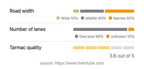
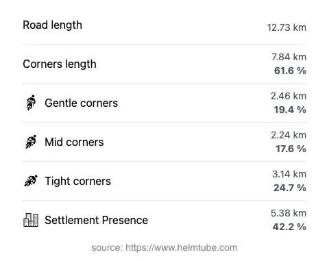
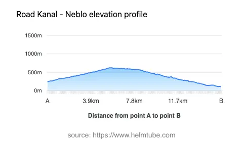
The Kanal–Neblo road extends for approximately 12.7 km (7.9 miles), offering a moderately twisty riding experience. The road surface is asphalt, with a quality rating that can be described as fair to good, though some sections may require increased attention due to surface irregularities. The route is predominantly single-lane (about 95%), with the majority of the road being either narrow (47%) or of medium width (42%). Only a small portion (about 5%) is considered wide. Riders should be prepared for variable lane widths and occasional tight passages, especially in the more mountainous segments. The elevation ranges from 102 m (335 ft) at its lowest point to 623 m (2,044 ft) at its highest, providing moderate altitude changes and occasional viewpoints over the surrounding landscape.
Natural Features and Points of Interest
This route is notable for its proximity to the Soča River, which it follows for a short distance. The Soča is renowned for its emerald-green waters and is a popular destination for outdoor activities. The road also crosses the Julian Alps, offering riders views of the rugged alpine terrain. Along the way, there are several viewpoints where riders can pause to appreciate the landscape. The settlements along the route, such as Kanal, are known for their traditional architecture and local culture, providing opportunities for brief stops and exploration. The region is less frequented by international tourists, making it an appealing choice for riders seeking a quieter experience.
Practical Considerations: Closures, Tolls, and Seasonal Access
There are currently no known restrictions or closures specific to motorcycles on the Kanal–Neblo route. The road remains open throughout the year, though riders should be aware that winter conditions in the Julian Alps can lead to temporary closures or hazardous riding conditions due to snow or ice. It is advisable to check local traffic updates before planning a ride during the colder months. There are no tolls or entrance fees required to use this road, but toll conditions may change in the future. For up-to-date information on road tolls and entrance fees in Slovenia, refer to the official DARS website.
Summary and Interactive Map
The Kanal–Neblo route offers a moderately challenging ride through a less-traveled part of Slovenia, combining technical road features with the natural beauty of the Julian Alps and the Soča River. Its variable road widths and fair surface quality require attentive riding, but the rewards include alpine views and a sense of remoteness. For those interested in exploring this region, an interactive map of the route is available below.
Explore the Region: Roads Close By
Discover more amazing roads located near the route featured in this article. The list below highlights nearby routes that are perfect for extending your ride or planning your next adventure.
Ride the Best: Slovenia’s Top Motorcycle Roads
These are the best motorbiking roads in Slovenia. The list below shows links to articles about top-rated motorcycle routes in the country. Explore the most popular roads in Slovenia and plan your next unforgettable motorbike adventure.