Exploring the Kindberg–Turnau Alpine Route: A Motorcyclist’s Guide
Locals know best!
If you travel this road often or live close by you will be given a chance to provide your valuable rating soon! Sign in and stay connected.Location and Geographic Context
The Kindberg–Turnau road is situated in the Austrian state of Styria, forming a connection between the town of Kindberg and the village of Turnau. The route traverses the Mürzsteger Alpen, a subrange of the Eastern Alps, and is recognized for its passage through alpine landscapes. The road’s alignment follows local thoroughfares such as Poguschstraße, Hauptstraße, and Landstraße, providing access to both inhabited and remote mountainous areas. An interactive map showing the road’s course can be found at the end of this article.
Road Characteristics and Riding Experience
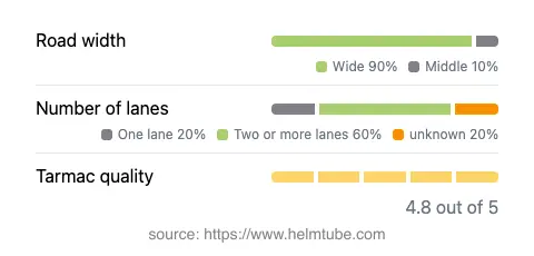
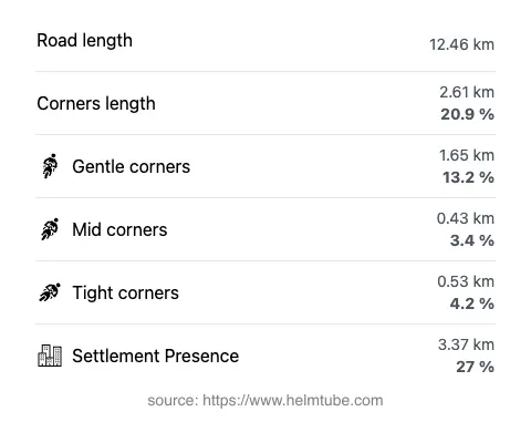
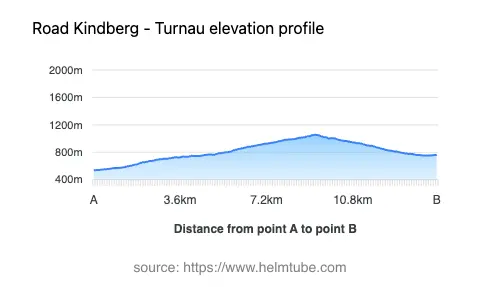
The Kindberg–Turnau route extends for approximately 12.5 km (7.8 miles), with elevations ranging from 537 m (1,762 ft) at its lowest point to 1,054 m (3,458 ft) at its highest. The road is predominantly wide (about 90%), with the remainder featuring medium-width sections. Most of the route consists of two lanes, while a smaller portion is single-lane. The surface is asphalt and is generally rated as excellent, offering a smooth ride for motorcycles. The road is moderately curvy, presenting a mix of gently winding sections and straighter stretches, making it accessible for riders of varying skill levels. About 27% of the route passes through inhabited areas, while the remainder traverses forested and mountainous terrain. Speed limits vary, with sections posted at 50 km/h (31 mph) in settlements and up to 100 km/h (62 mph) in open areas.
Mountain Range and Natural Attractions
This road is notable for crossing the Mürzsteger Alpen, a less-traveled part of the Alps known for its forested slopes and alpine meadows. The region is characterized by its natural beauty and relative tranquility compared to more frequented alpine passes. Riders may encounter panoramic views of the surrounding peaks and valleys, particularly near the higher elevations. The area is also home to several hiking trails and nature reserves, making it a point of interest for those seeking outdoor activities beyond motorcycling.
Road Closures and Seasonal Considerations
The Kindberg–Turnau road is generally open to motorcycles throughout the year. However, due to its elevation and alpine location, winter conditions can lead to temporary closures or hazardous riding surfaces, especially after heavy snowfall or during periods of ice. Riders are advised to check local traffic reports and weather forecasts before planning a journey, particularly in late autumn, winter, and early spring. There are no known event-related closures affecting this route on a regular basis.
Tolls, Fees, and Practical Information
There are currently no tolls or entrance fees required for motorcycles on the Kindberg–Turnau road. Riders should be aware that toll conditions may change in the future, and it is advisable to consult official resources for the most up-to-date information. For comprehensive details on road tolls and fees in Austria, visit the ASFINAG website. Fuel stations and basic amenities are available in Kindberg and Turnau, but services are limited along the route itself. Riders should plan accordingly, especially when traveling outside of peak tourist seasons.
Explore the Region: Roads Close By
Discover more amazing roads located near the route featured in this article. The list below highlights nearby routes that are perfect for extending your ride or planning your next adventure.
Ride the Best: Austria’s Top Motorcycle Roads
These are the best motorbiking roads in Austria. The list below shows links to articles about top-rated motorcycle routes in the country. Explore the most popular roads in Austria and plan your next unforgettable motorbike adventure.