Exploring the Kranj–Jezersko Alpine Route: A Motorcyclist’s Guide
Locals know best!
If you travel this road often or live close by you will be given a chance to provide your valuable rating soon! Sign in and stay connected.Location and Overview of the Kranj–Jezersko Alpine Route
The Kranj–Jezersko Alpine Route is situated in northern Slovenia, beginning near the city of Kranj and culminating in the village of Zgornje Jezersko. The road passes through several settlements, including Tupaliče, Celarjev most, and Leskovčev most, before reaching its terminus. This route lies within the Ljubljanska kotlina basin and crosses the Kamniško-Savinjske Alpe, a subrange of the Alps. The proximity to Kranj, a significant urban center, ensures accessibility, while the transition into the alpine environment provides a marked change in landscape and riding conditions. An interactive map showing the route is available at the end of this article.
Road Characteristics and Riding Experience
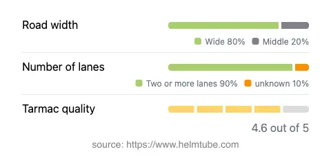
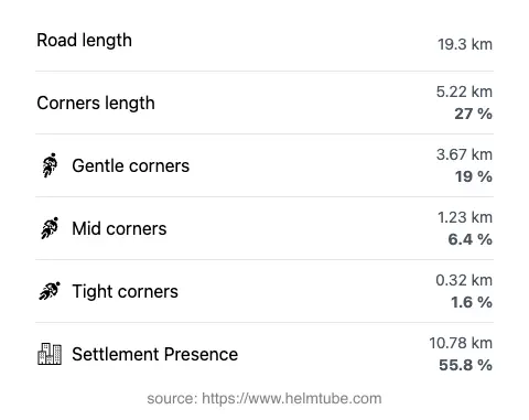
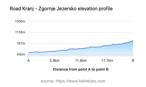
The Kranj–Jezersko Alpine Route extends for approximately 19.3 km (12 miles), with elevations ranging from 457 m (1,499 ft) to 851 m (2,792 ft). The road surface is asphalt and is generally of high quality, rated as excellent by most standards. The route is moderately curvy, offering a mix of gently curved and more technical sections, suitable for riders who appreciate variety without excessive challenge. Most of the road is wide (about 80%), with the remainder being of medium width. Two lanes are present along the vast majority of the route (about 94%), ensuring comfortable passage for both directions of traffic. The speed limits vary between 50 km/h (31 mph) and 70 km/h (43 mph), reflecting the transition from inhabited areas to open mountain stretches. Approximately 55.8% of the route passes through inhabited areas, providing opportunities for rest stops and services along the way.
Mountain Setting and Points of Interest
This road is notable for its passage through the Kamniško-Savinjske Alpe, a mountain range known for its rugged peaks and alpine valleys. The endpoint, Zgornje Jezersko, is a picturesque village renowned for its traditional alpine architecture and proximity to natural attractions such as Lake Planšar and the Jezersko–Solčava road. The route also provides access to hiking trails and viewpoints within the Alps. Riders may wish to explore the local culture and cuisine in the settlements along the way, particularly in Kranj, which is known for its historical old town and vibrant cultural scene.
Road Closures, Seasonal Access, and Regulations
The Kranj–Jezersko Alpine Route is generally open to motorcycles throughout the year. However, due to its alpine location and elevation, temporary closures can occur during periods of heavy snowfall or adverse weather, particularly in winter months. Riders are advised to check local traffic updates and weather forecasts before planning their journey. There are no permanent restrictions for motorcycles on this route. Event-related closures are rare but may occur during local festivals or road maintenance operations. For up-to-date information on road conditions and closures, consult the Slovenian Traffic Information Center.
Tolls, Fees, and Further Resources
There are currently no tolls or entrance fees required for motorcycles on the Kranj–Jezersko Alpine Route. Riders should note that toll conditions may change in the future, and it is advisable to verify the latest information before travel. For comprehensive details on road tolls and vignettes in Slovenia, visit the DARS (Motorway Company in the Republic of Slovenia) website. Additional travel resources and local attractions can be found on Lonely Planet Slovenia and Tripadvisor Slovenia.
Explore the Region: Roads Close By
Discover more amazing roads located near the route featured in this article. The list below highlights nearby routes that are perfect for extending your ride or planning your next adventure.
Ride the Best: Slovenia’s Top Motorcycle Roads
These are the best motorbiking roads in Slovenia. The list below shows links to articles about top-rated motorcycle routes in the country. Explore the most popular roads in Slovenia and plan your next unforgettable motorbike adventure.