Exploring the Labin–Mošćenička Draga Road: A Motorcyclist’s Guide
Locals know best!
If you travel this road often or live close by you will be given a chance to provide your valuable rating soon! Sign in and stay connected.Location and Overview
The Labin–Mošćenička Draga road is situated in the northern Adriatic region of Croatia, traversing the eastern edge of the Istrian peninsula. The route begins near the historic town of Labin and concludes at the coastal village of Mošćenička Draga. Along the way, it passes through smaller settlements such as Plomin and Majčevo, offering riders a transition from inland hills to the Adriatic coastline. The road’s proximity to the Kvarner Gulf provides frequent opportunities for sea views, while the surrounding landscape features Mediterranean vegetation and rolling hills. An interactive map showing the route can be found at the end of this article.
Road Characteristics and Riding Experience
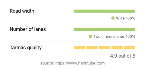
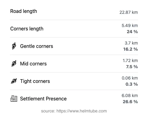
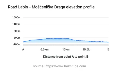
The Labin–Mošćenička Draga road extends for approximately 22.9 km (14.2 miles), with an elevation range from 26 m (85 ft) to 269 m (883 ft). The road surface is asphalt and is generally rated as excellent, providing a smooth and predictable riding experience. The route is moderately curvy, with a mix of gently curved and occasionally tighter bends, making it suitable for riders of varying skill levels. The majority of the road (about 97%) features two lanes, and it is predominantly wide (about 94%), allowing for comfortable overtaking and maneuvering. Only a small portion (about 3%) is single-lane, and narrow sections are virtually absent. The road passes through inhabited areas for roughly a quarter of its length, with the remainder offering open countryside and coastal vistas. Speed limits vary along the route, ranging from 30 km/h (19 mph) in village zones to up to 90 km/h (56 mph) on open stretches.
Attractions and Viewpoints Along the Route
This road is notable for its series of viewpoints overlooking the Kvarner Gulf and the surrounding Istrian landscape. Riders can expect several designated stops that provide panoramic views of the Adriatic Sea and the nearby islands. The town of Labin, known for its medieval old town and cultural heritage, serves as a gateway to the route. At the other end, Mošćenička Draga is a picturesque coastal village with a pebble beach and a traditional fishing harbor. The road also skirts the vicinity of Plomin, a settlement perched above the sea, offering additional opportunities for exploration. The viewpoints along the route are popular stops for photography and short breaks, especially during clear weather when the visibility across the gulf is at its best.
Road Closures, Seasonal Considerations, and Regulations
The Labin–Mošćenička Draga road is open to motorcycles throughout the year and is not subject to regular seasonal closures. Temporary closures may occur due to roadworks or local events, but these are typically announced in advance by local authorities. Riders should be aware that weather conditions can affect riding comfort, particularly during the summer months when temperatures can be high, and during occasional winter storms that may bring rain and reduced visibility. There are no known restrictions specific to motorcycles on this route. For up-to-date information on road conditions and potential closures, riders can consult the Croatian Automobile Club (HAK) website.
Tolls, Fees, and Practical Information
There are currently no tolls or entrance fees required to use the Labin–Mošćenička Draga road. The route is part of the public road network and is accessible to all vehicles, including motorcycles, without charge. Riders should note that toll conditions may change in the future, and it is advisable to verify the latest information before planning a trip. For comprehensive details on road tolls and fees in Croatia, including updates and exceptions, refer to the HAK toll rates page.
Explore the Region: Roads Close By
Discover more amazing roads located near the route featured in this article. The list below highlights nearby routes that are perfect for extending your ride or planning your next adventure.
Ride the Best: Croatia’s Top Motorcycle Roads
These are the best motorbiking roads in Croatia. The list below shows links to articles about top-rated motorcycle routes in the country. Explore the most popular roads in Croatia and plan your next unforgettable motorbike adventure.