Exploring the Makarska Hinterland Route: A Motorcyclist’s Guide
Locals know best!
If you travel this road often or live close by you will be given a chance to provide your valuable rating soon! Sign in and stay connected.Location and Overview of the Makarska Hinterland Route
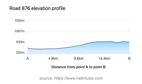
The Makarska Hinterland Route is situated in southern Croatia, running inland from the popular coastal town of Makarska. The road lies within the Split-Dalmatia County, an area known for its rugged karst terrain and proximity to the Biokovo mountain range. The route’s coordinates place it northeast of Makarska, extending through the hinterland between elevations of 344 m (1,129 ft) and 654 m (2,146 ft). This region is characterized by sparse settlements and open landscapes, making it a suitable choice for riders seeking less congested roads. An interactive map showing the route is available at the end of this article.
Road Details and Riding Experience
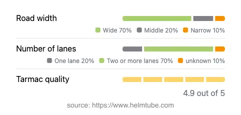
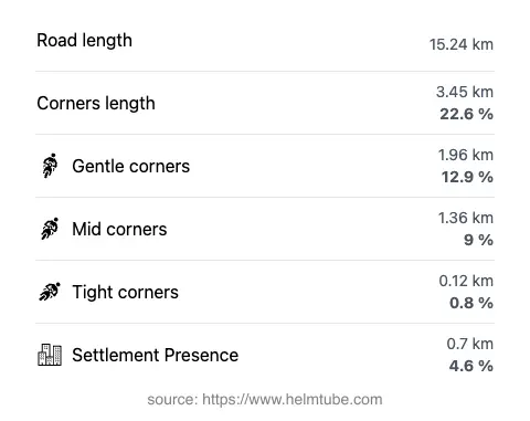
The Makarska Hinterland Route covers a distance of approximately 15.2 km (9.4 miles). The road surface is asphalt and is generally of excellent quality, providing a smooth ride for most motorcycles. Riders will encounter a mix of gently curved and moderately twisty sections, with the majority of the road offering two lanes (about 65%) and a wide carriageway (about 64%). Narrower segments are limited, and only a small proportion of the route passes through inhabited areas (approximately 4.6%), allowing for uninterrupted riding. The elevation change from 344 m (1,129 ft) to 654 m (2,146 ft) offers occasional panoramic views of the surrounding countryside and the distant Biokovo massif. The road’s layout and surface make it accessible to both experienced and less experienced riders.
Attractions and Points of Interest Along the Route
While the Makarska Hinterland Route itself is primarily a transit road, its proximity to several attractions enhances its appeal. The nearby Biokovo Nature Park is a highlight, offering opportunities for hiking and panoramic views from the Biokovo Skywalk. The coastal town of Makarska is renowned for its beaches and vibrant promenade. Riders may also consider a detour to the village of Imotski, famous for its Blue and Red Lakes. These attractions are uniquely tied to the region and can be incorporated into a day’s ride.
Road Closures, Tolls, and Practical Information
The Makarska Hinterland Route is open to motorcycles year-round, with no regular seasonal closures reported. However, weather conditions in winter, particularly fog or occasional snow at higher elevations, may affect riding safety. There are no tolls or entrance fees required to use this road, but toll conditions in Croatia may change in the future. For the most current information on road tolls and fees, riders should consult the official Croatian Motorways website. Event-related closures are rare, but local authorities may implement temporary restrictions for maintenance or public events.
Planning Your Ride and Map Access
Riders planning to explore the Makarska Hinterland Route should ensure their motorcycles are in good condition, as fuel stations and services are limited along the route. The road’s excellent surface and moderate curves make it suitable for a range of motorcycle types. For navigation, GPS devices or smartphone apps are recommended, as signage may be sparse in rural sections. An interactive map of the route is available below to assist with trip planning and orientation.
Explore the Region: Roads Close By
Discover more amazing roads located near the route featured in this article. The list below highlights nearby routes that are perfect for extending your ride or planning your next adventure.
Ride the Best: Croatia’s Top Motorcycle Roads
These are the best motorbiking roads in Croatia. The list below shows links to articles about top-rated motorcycle routes in the country. Explore the most popular roads in Croatia and plan your next unforgettable motorbike adventure.