Exploring the Malostonski Zaljev Coastal Road: A Motorcycle Route Through Croatia’s Unique Marine Reserve
Locals know best!
If you travel this road often or live close by you will be given a chance to provide your valuable rating soon! Sign in and stay connected.Location and Setting of the Malostonski Zaljev Coastal Road
Lokalna cesta 69030 is situated in southern Croatia, running adjacent to the Malostonski zaljev (Mali Ston Bay) and the Malo more, a narrow channel that separates the Pelješac Peninsula from the mainland. The road passes through the Malostonski zaljev i Malo more Special Nature Reserve, an area recognized for its unique marine and coastal ecosystems. The nearest major settlement to both the starting and ending points is the town of Neum, located just a few kilometers away. The route follows the contours of the bay, offering views of oyster farms, salt pans, and the tranquil waters of the Adriatic. An interactive map showing the road’s precise location can be found at the end of this article.
Road Characteristics and Riding Experience
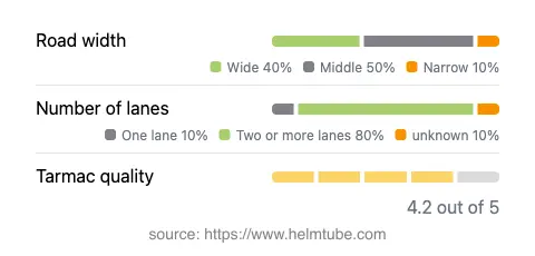
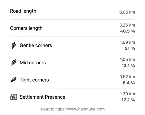
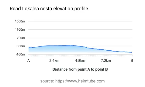
The Malostonski Zaljev Coastal Road extends for approximately 8.05 km (5 miles), with elevations ranging from just 3 m (10 ft) above sea level to a maximum of 346 m (1,135 ft). The road is predominantly surfaced with asphalt of good quality, providing a comfortable ride for most motorcycles. Riders will encounter a route that is moderately twisty, with a mix of gently curved and occasionally sharper bends as the road follows the natural contours of the coastline and valley. The majority of the road features two lanes (about 80%), with the remainder consisting of narrower sections. Road width varies, with most of the route being of medium or wide width (about 90%), allowing for safe passing and maneuvering. Only a small proportion of the road passes through inhabited areas, ensuring a largely uninterrupted riding experience. Speed limits along the route are generally low, ranging from 20 to 40 km/h (12 to 25 mph), reflecting the protected status of the area and the need for caution due to wildlife and local traffic.
Natural Attractions and Points of Interest
The primary attraction along this route is the Malostonski zaljev i Malo more Special Nature Reserve, a region celebrated for its biodiversity, traditional oyster and mussel farming, and pristine coastal landscapes. The bay is a designated Ramsar wetland and is home to a variety of bird species and marine life. Riders may also observe the historic salt pans of Ston and the medieval walls of Ston nearby, although these are not directly on the road but are accessible via short detours. The proximity to the town of Neum provides opportunities for rest, refreshments, and exploration of local culture. The road’s passage through a valley and along the coastline ensures a varied landscape, with frequent views of the sea and surrounding hills.
Access, Closures, and Regulations
Lokalna cesta 69030 is open to motorcycles and other vehicles, with no regular seasonal closures reported. However, as the road passes through a protected nature reserve, temporary closures or restrictions may occur due to environmental protection measures or special events. Riders are advised to check for any updates or notices from local authorities before planning their journey. There are currently no tolls or entrance fees specifically for using this road, but conditions may change in the future. For the most up-to-date information on road tolls and entrance fees in Croatia, consult the official resource at Hrvatske autoceste. Motorcyclists should also be aware of the low speed limits and the need to respect the sensitive environment of the nature reserve.
Planning Your Ride and Interactive Map
When planning a motorcycle trip along the Malostonski Zaljev Coastal Road, it is advisable to prepare for variable weather conditions, especially given the proximity to the sea and the potential for strong winds. The road’s good surface quality and moderate traffic levels make it suitable for riders of varying experience. Facilities are limited along the route itself, so refueling and refreshments should be arranged in advance, particularly in Neum or nearby settlements. For navigation and route planning, an interactive map of the road is available below, providing detailed information on the route’s alignment and key points of interest.
Explore the Region: Roads Close By
Discover more amazing roads located near the route featured in this article. The list below highlights nearby routes that are perfect for extending your ride or planning your next adventure.
Ride the Best: Croatia’s Top Motorcycle Roads
These are the best motorbiking roads in Croatia. The list below shows links to articles about top-rated motorcycle routes in the country. Explore the most popular roads in Croatia and plan your next unforgettable motorbike adventure.