Exploring the Malta Hochalmstraße: A Technical Ride Through Austria’s Maltatal
Locals know best!
If you travel this road often or live close by you will be given a chance to provide your valuable rating soon! Sign in and stay connected.Location and Setting of the Malta Hochalmstraße
The Malta Hochalmstraße is located in the Austrian state of Carinthia, traversing the Maltatal valley in the Oberkärnten region. The road begins near the village of Malta and ascends into the high alpine landscape, running entirely within the boundaries of the Alps and specifically crossing the Ankogelgruppe mountain range. The route is situated in a region known for its dramatic mountain scenery and is easily accessible from the town of Gmünd. An interactive map showing the precise route of the Malta Hochalmstraße can be found at the end of this article.
Road Characteristics and Riding Experience
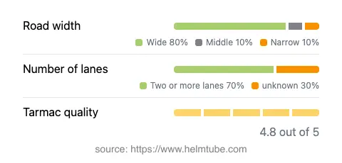
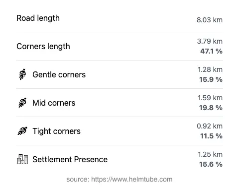
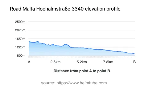
The Malta Hochalmstraße extends for approximately 8 km (5 miles), with the majority of the route featuring a wide, well-maintained asphalt surface. The road is predominantly two lanes wide (about 67%), with the remainder consisting of narrower sections. Riders will encounter a very twisty alignment, making it particularly appealing for those who enjoy technical riding. The elevation ranges from 912 m (2,992 ft) at its lowest point to 1,511 m (4,957 ft) at its highest, offering a significant vertical gain over a relatively short distance. The maximum speed limit is 30 km/h (19 mph), reflecting the road’s sharp bends and the need for caution, especially in the narrower segments. Surface quality is generally excellent, providing good grip and confidence for motorcyclists throughout the ascent.
Scenic Attractions and Viewpoints Along the Route
The Malta Hochalmstraße is renowned for its series of viewpoints, each offering expansive views of the surrounding peaks and valleys. The road passes through the heart of the Maltatal, also known as the "Valley of Falling Waters" due to its numerous waterfalls. Notable attractions along the route include the Kölnbrein Dam, Austria’s highest dam, which marks the terminus of the road and provides a dramatic backdrop for photographs and rest stops. The Ankogelgruppe mountain range, part of the Central Eastern Alps, dominates the landscape and is a popular destination for hikers and climbers. Riders can also enjoy panoramic views of the Hafnergruppe and the broader Alps, making this road a highlight for those interested in alpine geography and natural beauty.
Road Closures, Seasonal Access, and Toll Information
The Malta Hochalmstraße is typically open to motorcyclists from late spring to early autumn, with closures common during the winter months due to snow and adverse weather conditions. Temporary closures may also occur for maintenance or special events. The road is a private toll road, and all vehicles, including motorcycles, are required to pay an entrance fee. Toll conditions may change in the future, so it is advisable to check the latest information before planning a trip. For up-to-date details on tolls and seasonal access, consult the official Austrian toll information portal at ASFINAG.
Planning Your Ride: Practical Considerations
Given its alpine location and technical nature, riders should be prepared for rapidly changing weather conditions and ensure their motorcycles are in good mechanical condition. The road’s limited width in some sections and the presence of tourist traffic, especially during peak season, require heightened attention. Facilities such as parking areas, rest stops, and cafes are available near the Kölnbrein Dam, providing opportunities to rest and enjoy the surroundings. For those interested in extending their visit, the region offers additional attractions such as the Ankogel Group and the picturesque town of Gmünd. The Malta Hochalmstraße remains a must-ride for motorcyclists seeking a blend of technical riding and alpine scenery.
Explore the Region: Roads Close By
Discover more amazing roads located near the route featured in this article. The list below highlights nearby routes that are perfect for extending your ride or planning your next adventure.
Ride the Best: Austria’s Top Motorcycle Roads
These are the best motorbiking roads in Austria. The list below shows links to articles about top-rated motorcycle routes in the country. Explore the most popular roads in Austria and plan your next unforgettable motorbike adventure.