Exploring the Markovščina–Ilirska Bistrica Route: A Motorcyclist’s Guide
Locals know best!
If you travel this road often or live close by you will be given a chance to provide your valuable rating soon! Sign in and stay connected.Location and Regional Context
The Markovščina–Ilirska Bistrica road is situated in southwestern Slovenia, beginning in the village of Markovščina and ending in the town of Ilirska Bistrica. The route passes through several small settlements, including Podgrad, Obrov, Račice, and Gradišče pri Materiji. The road traverses two distinct regions: the Podgrajsko podolje valley and the Brkini hills, both known for their rural character and traditional Slovenian landscapes. An interactive map showing the route can be found at the end of this article.
Road Characteristics and Riding Experience
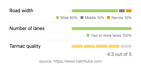
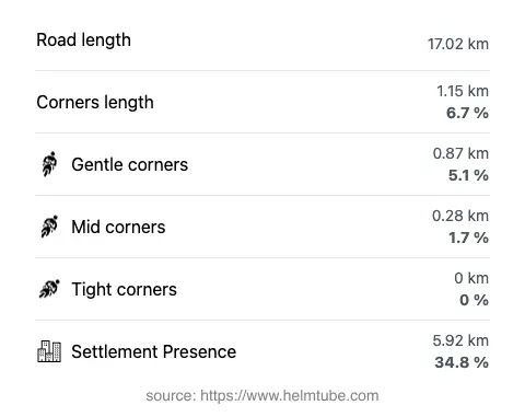
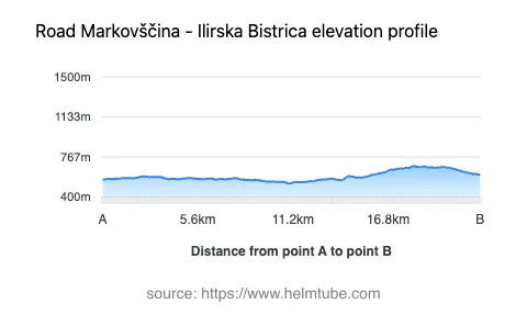
This road extends for approximately 17 km (10.6 miles), offering a relatively gentle ride with only mild curves along most of its length. The surface is asphalt and is generally of good quality, providing a comfortable experience for most motorcycles. The road is predominantly wide (about 82%), with some sections of medium width and a small proportion that is narrow. Two lanes are present along nearly the entire route (about 96%), supporting smooth two-way traffic. The elevation ranges from 525 m (1,722 ft) at its lowest point to 684 m (2,244 ft) at its highest, with gradual changes in altitude rather than steep climbs or descents. The road passes through inhabited areas for roughly a third of its length, giving riders occasional glimpses of local life in the settlements it connects.
Speed Limits and Traffic Considerations
Speed limits along the Markovščina–Ilirska Bistrica road vary depending on the section, with posted limits of 50 km/h (31 mph), 90 km/h (56 mph), 40 km/h (25 mph), and 70 km/h (43 mph). These limits reflect the changing character of the road as it passes through villages, open countryside, and more developed areas. Traffic is typically light, especially outside of peak commuting hours, making it suitable for riders seeking a relaxed journey. The road’s gentle curves and good surface quality make it accessible to riders of all experience levels, though caution is advised in inhabited zones and at intersections with local roads.
Tourist Attractions and Points of Interest
While the Markovščina–Ilirska Bistrica route is not widely known for major tourist attractions, it offers access to the rural charm of the Brkini region, an area recognized for its orchards, rolling hills, and traditional villages. The town of Ilirska Bistrica at the southern end of the route serves as a gateway to the Snežnik plateau and the Snežnik Castle, a notable historic site located a short ride to the east. Riders interested in local culture may also explore the smaller settlements along the route, each offering a glimpse into the region’s agricultural traditions and rural architecture.
Practical Information: Closures, Tolls, and Seasonal Access
The Markovščina–Ilirska Bistrica road is open to motorcycles year-round and is not subject to regular seasonal closures. Temporary closures may occur due to roadworks or local events, but these are infrequent and typically well-signposted. There are currently no tolls or entrance fees required to use this road. Riders should be aware that toll conditions in Slovenia may change in the future; for the most up-to-date information on road tolls and vignettes, consult the official DARS website. Standard safety precautions apply, and riders are encouraged to check local traffic updates before setting out.
Explore the Region: Roads Close By
Discover more amazing roads located near the route featured in this article. The list below highlights nearby routes that are perfect for extending your ride or planning your next adventure.
Ride the Best: Slovenia’s Top Motorcycle Roads
These are the best motorbiking roads in Slovenia. The list below shows links to articles about top-rated motorcycle routes in the country. Explore the most popular roads in Slovenia and plan your next unforgettable motorbike adventure.