Exploring the Metlika–Božakovo Road: A Motorcyclist’s Guide Along the Kupa River
Locals know best!
If you travel this road often or live close by you will be given a chance to provide your valuable rating soon! Sign in and stay connected.Location and Setting of the Metlika–Božakovo Road
The Metlika–Božakovo road is situated in southeastern Slovenia, close to the border with Croatia. The route begins near the town of Metlika and proceeds towards Božakovo, passing through settlements such as Cankarjeva cesta and Rosalnice. The road skirts the edge of the Park prirode Žumberak – Samoborsko gorje, a protected natural area known for its diverse landscapes and rich biodiversity. The Kupa River, which forms part of the border between Slovenia and Croatia, runs adjacent to the road for a significant portion of the journey. An interactive map showing the precise route of the Metlika–Božakovo road can be found at the end of this article.
Road Characteristics and Riding Experience
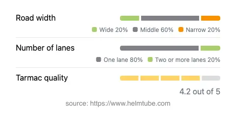
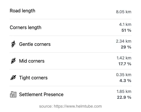
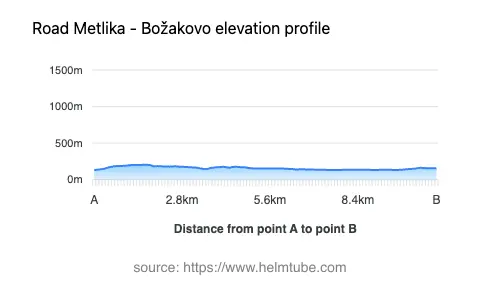
The Metlika–Božakovo road extends for approximately 8.1 km (5 miles), offering a moderately curvy riding experience. The road surface is asphalt and is generally of good quality, providing a comfortable ride for most motorcycles. Riders will encounter a mix of one-lane (about 80%) and two-lane (about 17%) sections, with the majority of the road being of medium width (about 53%). Narrow and wide sections are also present, accounting for smaller portions of the route. The elevation ranges from 132 m (433 ft) to 204 m (669 ft), resulting in gentle elevation changes rather than steep climbs or descents. The road passes through inhabited areas for roughly 23% of its length, with the remainder traversing rural and natural landscapes. The proximity to the Kupa River (about 29% of the route) adds to the appeal for those interested in riverside riding. The nearest major settlements are Ozalj, located approximately 6.9 km (4.3 miles) from the starting point, and Metlika, just 0.3 km (0.2 miles) from the end of the route.
National Park Proximity and Points of Interest
One of the defining features of this road is its proximity to the Park prirode Žumberak – Samoborsko gorje. Although the road only touches the edge of the park, riders can easily access the park’s trails and viewpoints. The park is recognized for its rolling hills, forests, and traditional rural settlements, making it a worthwhile detour for those interested in nature and local culture. The Kupa River, which the road follows for a portion of its length, is another notable feature. The river is known for its clean waters and opportunities for outdoor activities such as fishing and kayaking. The town of Metlika, near the end of the route, is also of interest, with its historic center and the Metlika Castle providing cultural and historical context to the journey.
Road Closures, Seasonal Considerations, and Regulations
There are currently no known restrictions or closures specific to motorcycles on the Metlika–Božakovo road. The route is not subject to regular winter closures, as it is located at relatively low elevations and serves as a local connector. However, riders should be aware that weather conditions can affect road safety, particularly during periods of heavy rain or flooding along the Kupa River. Event-related closures are rare but may occur during local festivals or maintenance works. It is advisable to check local traffic information before planning a ride, especially during adverse weather conditions or public events.
Tolls, Fees, and Additional Information
The Metlika–Božakovo road does not currently require the payment of a toll or entrance fee for motorcycles or other vehicles. However, toll conditions may change in the future, and riders are encouraged to verify the latest information before their trip. For up-to-date details on road tolls and entrance fees in Slovenia, consult the official website of DARS, the national motorway company. This resource provides comprehensive information on toll requirements, payment methods, and any changes to the tolling system.
Explore the Region: Roads Close By
Discover more amazing roads located near the route featured in this article. The list below highlights nearby routes that are perfect for extending your ride or planning your next adventure.
Ride the Best: Slovenia’s Top Motorcycle Roads
These are the best motorbiking roads in Slovenia. The list below shows links to articles about top-rated motorcycle routes in the country. Explore the most popular roads in Slovenia and plan your next unforgettable motorbike adventure.