Exploring the D120: The Island Artery of Mljet
Locals know best!
If you travel this road often or live close by you will be given a chance to provide your valuable rating soon! Sign in and stay connected.Location and Route Overview
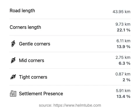
The D120 road is situated entirely on Mljet, an island in southern Croatia. Stretching from the eastern village of Saplunara to the western settlement of Pomena, the road covers approximately 44 km (27.3 miles). The route passes through the core of the island, connecting small villages and providing access to the island’s coastline and interior. The D120 is the main thoroughfare for all vehicular traffic on Mljet, making it essential for both residents and tourists. An interactive map showing the full route of the D120 can be found at the end of this article.
Road Characteristics and Riding Experience
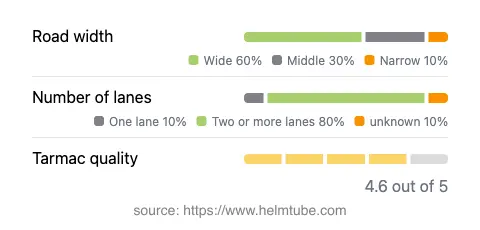
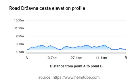
The D120 is predominantly a two-lane road (about 83%), with the remainder consisting of narrower sections. The road width varies, with wide stretches making up the majority (about 52%), complemented by middle and narrow segments. The surface is asphalt and generally of high quality, rated as excellent by most standards. Riders will encounter a moderately curvy route, offering a balance between straight sections and gentle bends, suitable for a relaxed touring pace. Elevation ranges from 10 m (33 ft) near the coast to a maximum of 253 m (830 ft) inland, providing occasional elevation changes but no steep mountain passes. The road passes through inhabited areas for a small portion (13.4%), ensuring that most of the ride is through natural landscapes.
National Park and Attractions Along the D120
A significant portion of the D120 passes through Mljet National Park, a protected area known for its dense forests, saltwater lakes, and unique biodiversity. The road provides direct access to the park’s main attractions, including the famous Malo jezero (Small Lake), a picturesque bay with clear waters and popular viewpoints. The proximity to these natural features makes the D120 a favored route for those seeking to explore the island’s highlights. Viewpoints along the road offer opportunities to stop and appreciate the landscape, with several marked spots providing panoramic views of the lakes and coastline.
Traffic, Speed Limits, and Seasonal Considerations
Speed limits on the D120 vary depending on the section, ranging from 20 km/h (12 mph) in village zones to 90 km/h (56 mph) on open stretches. Traffic is generally light outside the peak summer months, but can increase significantly during the tourist season, especially near the entrances to Mljet National Park and popular attractions. There are no known permanent closures for motorcycles, but temporary restrictions may occur due to park events or maintenance. The road remains open year-round, with no regular winter closures, although weather conditions can occasionally affect accessibility. Riders should be aware of local regulations and check for any event-related closures before planning their journey.
Tolls, Fees, and Practical Information
There is no toll for using the D120 itself. However, entry to Mljet National Park requires a ticket, with prices varying by season and visitor category. These fees are subject to change, and it is advisable to consult the official park website for the most current information. For broader details on road tolls and entrance fees in Croatia, refer to the Croatian Automobile Club (HAK) website. Motorcyclists should also note that ferry transport is required to reach Mljet from the mainland, with schedules and fares available through local ferry operators.
Explore the Region: Roads Close By
Discover more amazing roads located near the route featured in this article. The list below highlights nearby routes that are perfect for extending your ride or planning your next adventure.
Ride the Best: Croatia’s Top Motorcycle Roads
These are the best motorbiking roads in Croatia. The list below shows links to articles about top-rated motorcycle routes in the country. Explore the most popular roads in Croatia and plan your next unforgettable motorbike adventure.