Exploring the Mokronog–Šentjernej Route: A Technical Overview for Motorcyclists
Locals know best!
If you travel this road often or live close by you will be given a chance to provide your valuable rating soon! Sign in and stay connected.Location and Regional Context
The Mokronog–Šentjernej route is situated in the southeastern part of Slovenia, traversing the Lower Carniola region. The road links the village of Mokronog with the town of Šentjernej, passing through a series of small settlements including Zbure, Škocjan, Dobruška vas, Dolnja Stara vas, Zavinek, Zalog pri Škocjanu, and Grmovlje. The area is characterized by rolling hills, agricultural landscapes, and a network of rural communities. The nearest larger town to the starting point is Kostanjevica na Krki, located approximately 9.3 km (5.8 miles) away. An interactive map showing the route can be found at the end of this article.
Road Characteristics and Riding Experience
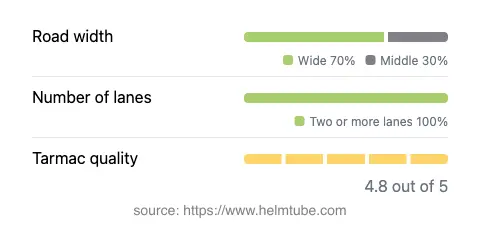
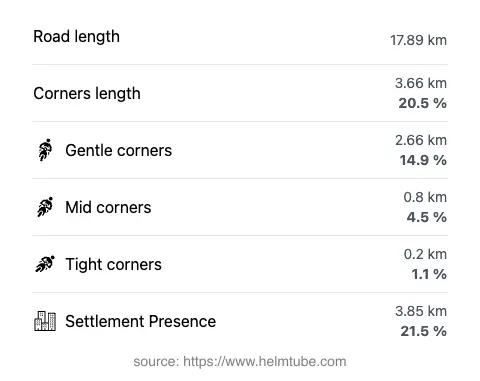
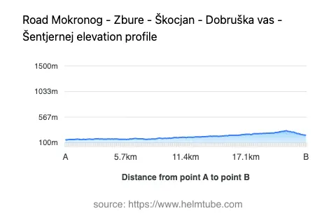
The Mokronog–Šentjernej route extends for approximately 17.9 km (11.1 miles), offering a predominantly wide, two-lane asphalt surface. The road is gently curved, with a curviness rating that suggests moderate bends suitable for relaxed touring rather than aggressive cornering. Surface quality is rated as excellent, providing a smooth ride for motorcycles. The elevation ranges from 155 m (509 ft) to 321 m (1,053 ft), with gradual changes in altitude that do not present significant challenges. About 70% of the route is considered wide, with the remainder being of medium width. Inhabited areas account for roughly 21.5% of the total distance, so riders can expect a mix of open countryside and small village environments.
Points of Interest Along the Route
While the route itself is primarily functional, it passes near several points of local interest. The town of Šentjernej is known for its historic churches and annual cultural events. The nearby Kostanjevica na Krki is notable for its picturesque island setting and the Kostanjevica Monastery, which houses an art gallery and museum. The region is also recognized for its vineyards and traditional rural architecture, offering opportunities for brief stops and exploration.
Road Closures and Seasonal Considerations
There are no known restrictions for motorcycles on the Mokronog–Šentjernej route. The road remains open throughout the year, as it does not traverse high-altitude or mountainous terrain that would typically be subject to winter closures. Temporary closures may occur due to local events or maintenance, but these are infrequent and generally well-signposted. Riders are advised to check local traffic updates before departure for any short-term disruptions.
Tolls, Fees, and Practical Information
The Mokronog–Šentjernej route does not require the payment of tolls or entrance fees for motorcycles. It is part of the regional road network, which is generally toll-free for two-wheeled vehicles in Slovenia. However, toll conditions may change in the future, and riders should consult the official DARS website for the most current information regarding road charges and vignettes in Slovenia.
Explore the Region: Roads Close By
Discover more amazing roads located near the route featured in this article. The list below highlights nearby routes that are perfect for extending your ride or planning your next adventure.
Ride the Best: Slovenia’s Top Motorcycle Roads
These are the best motorbiking roads in Slovenia. The list below shows links to articles about top-rated motorcycle routes in the country. Explore the most popular roads in Slovenia and plan your next unforgettable motorbike adventure.