Exploring the Nova Gorica–Gorenja Vas Route: A Technical Overview for Motorcyclists
Locals know best!
If you travel this road often or live close by you will be given a chance to provide your valuable rating soon! Sign in and stay connected.Location and Geographic Context
The Nova Gorica–Gorenja vas road is situated in western Slovenia, beginning near the town of Nova Gorica and terminating at the village of Gorenja vas. The route passes through several settlements, including Bate, Grgarske Ravne, Kanalski Vrh, Morsko, and Grgar. This area is characterized by rolling hills and a mix of rural and semi-urban landscapes, lying close to the border with Italy. The region is known for its proximity to the Soča Valley, a popular destination for outdoor enthusiasts. An interactive map showing the precise route can be found at the end of this article.
Road Characteristics and Riding Experience
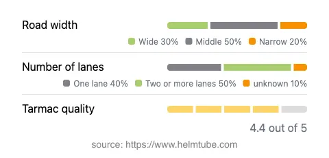
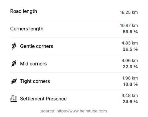
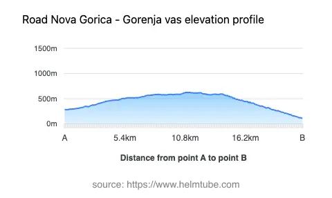
The Nova Gorica–Gorenja vas route extends for approximately 18.2 km (11.3 miles), offering a ride that is notably twisty, with a curviness rating close to the upper end of the scale. The road surface is asphalt and is generally of high quality, described as smooth and well-maintained. Riders will encounter a mix of one-lane and two-lane sections, with two-lane stretches making up about half of the route. The width varies, with the majority (about 45%) being of moderate width, while narrower and wider segments are also present. Elevation ranges from 112 m (367 ft) near Nova Gorica to a maximum of 626 m (2,054 ft), providing a moderate climb and descent profile. The route passes through inhabited areas for roughly a quarter of its length, offering occasional glimpses of local village life.
Local Attractions and Points of Interest
While the road itself is primarily used for transit between settlements, its proximity to the Soča Valley makes it an attractive option for riders interested in exploring the natural and cultural heritage of western Slovenia. The town of Nova Gorica serves as a gateway to the region, offering amenities and access to the Julian Alps. Along the route, settlements such as Grgar and Kanalski Vrh provide opportunities to experience rural Slovenian life. The area is also known for its historical significance, particularly related to World War I events in the Soča Valley.
Road Closures and Seasonal Considerations
There are no permanent closures for motorcycles on the Nova Gorica–Gorenja vas route. The road remains open throughout the year, although temporary closures may occur due to maintenance or adverse weather conditions, particularly in winter months when snow or ice can affect higher elevations. Riders are advised to check local traffic updates before departure, especially during periods of inclement weather or scheduled roadworks.
Tolls, Fees, and Practical Information
Currently, there are no tolls or entrance fees required to use the Nova Gorica–Gorenja vas road. However, toll conditions may change in the future, and riders should consult official resources for the most up-to-date information. For details on road tolls and vignettes in Slovenia, refer to the official DARS website. Standard traffic regulations apply, with speed limits typically set at 50 km/h (31 mph) in inhabited areas and up to 90 km/h (56 mph) on open rural stretches, unless otherwise indicated.
Interactive Map and Further Resources
For those interested in planning their ride, an interactive map of the Nova Gorica–Gorenja vas route is available below. Additional information about the region and its attractions can be found on resources such as Wikivoyage and Lonely Planet.
Explore the Region: Roads Close By
Discover more amazing roads located near the route featured in this article. The list below highlights nearby routes that are perfect for extending your ride or planning your next adventure.
Ride the Best: Slovenia’s Top Motorcycle Roads
These are the best motorbiking roads in Slovenia. The list below shows links to articles about top-rated motorcycle routes in the country. Explore the most popular roads in Slovenia and plan your next unforgettable motorbike adventure.