Exploring the Pečke–Slovenska Bistrica Route: A Motorcycle Guide
Locals know best!
If you travel this road often or live close by you will be given a chance to provide your valuable rating soon! Sign in and stay connected.Location and Overview
The Pečke–Slovenska Bistrica road is situated in northeastern Slovenia, connecting the village of Pečke with the town of Slovenska Bistrica. The route passes through the settlements of Novake and Dravinjska cesta, traversing a predominantly rural landscape. The road closely follows the Dravinja River for a significant portion of its length, offering riders a tranquil riverside experience. An interactive map showing the route can be found at the end of this article.
Road Characteristics and Riding Experience
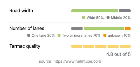
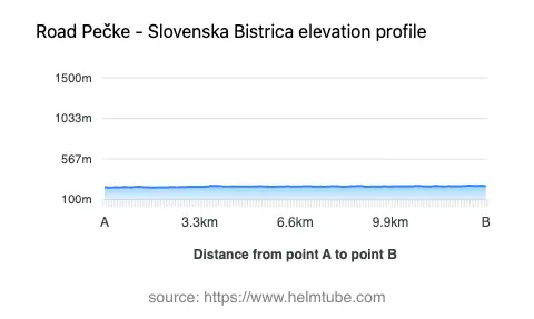
This road extends for approximately 10.2 km (6.3 miles), with the majority of its surface composed of high-quality asphalt. Riders will find the road to be gently curved, making it suitable for those who prefer a relaxed ride over more technical, twisty routes. The surface quality is rated as excellent, ensuring a comfortable journey. Most of the road is wide (about 75%), with a smaller portion being of medium width. Two lanes are present for the majority of the route (about 66%), while one-lane sections are less common. The elevation varies only slightly, ranging from 238 m (781 ft) to 262 m (860 ft), so there are no significant climbs or descents to challenge the rider.
Natural Features and Attractions
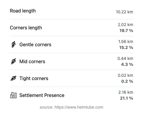
The Dravinja River is a defining feature of this route, running adjacent to the road for approximately 71% of its length. This proximity to the river provides a pleasant backdrop and occasional opportunities to stop and enjoy the riverside environment. The area is also home to at least one notable viewpoint, offering riders a chance to pause and take in the local scenery. For more information about the Dravinja River, visit Dravinja. The town of Slovenska Bistrica at the end of the route is known for its historical architecture and serves as a convenient stop for refreshments or exploration.
Traffic, Speed Limits, and Seasonal Considerations
The Pečke–Slovenska Bistrica road is open to motorcycles year-round, with no known seasonal closures. The maximum speed limits along the route are 50 km/h (31 mph) in inhabited areas and up to 90 km/h (56 mph) in rural sections. Traffic is generally light, especially outside of peak commuting hours, making it a suitable choice for riders seeking a less congested experience. There are no regular event-related closures reported for this road.
Tolls, Fees, and Practical Information
There are currently no tolls or entrance fees required to ride the Pečke–Slovenska Bistrica road. Riders should be aware that toll conditions may change in the future. For up-to-date information on road tolls and entrance fees in Slovenia, consult the official DARS website. The road is suitable for all types of motorcycles, and its excellent surface quality makes it accessible even for less experienced riders.
Explore the Region: Roads Close By
Discover more amazing roads located near the route featured in this article. The list below highlights nearby routes that are perfect for extending your ride or planning your next adventure.
Ride the Best: Slovenia’s Top Motorcycle Roads
These are the best motorbiking roads in Slovenia. The list below shows links to articles about top-rated motorcycle routes in the country. Explore the most popular roads in Slovenia and plan your next unforgettable motorbike adventure.