Exploring the Razdrto–Rožna dolina Route: A Motorcyclist’s Guide
Locals know best!
If you travel this road often or live close by you will be given a chance to provide your valuable rating soon! Sign in and stay connected.Location and Overview of the Razdrto–Rožna dolina Route
The Razdrto–Rožna dolina route is situated in southwestern Slovenia, traversing the edge of the Karst plateau and descending into the Vipava Valley. The road begins near the village of Razdrto, passes through Rebrnice, and concludes at Podnanos. This corridor serves as a connector between the interior of Slovenia and the coastal region, making it a strategic route for both local traffic and touring motorcyclists. The Vipava Valley, known locally as Vipavska dolina, is recognized for its unique microclimate and wine production. An interactive map showing the full extent of the Razdrto–Rožna dolina route can be found at the end of this article.
Road Characteristics and Riding Experience
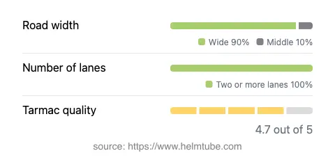
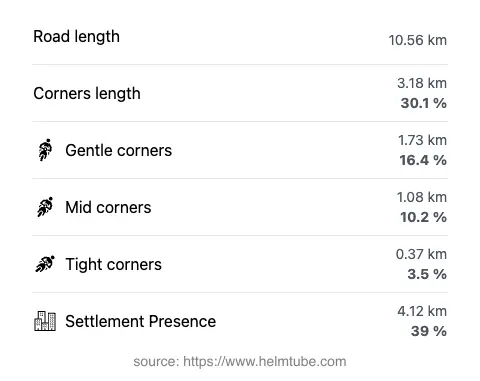
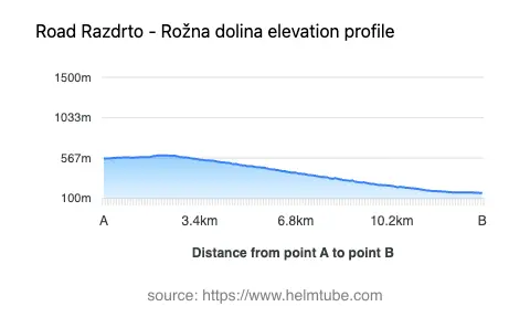
The Razdrto–Rožna dolina road extends for approximately 10.6 km (6.6 miles), with an elevation range from 162 m (531 ft) to 599 m (1,965 ft). The road surface is asphalt and is generally rated as high quality, with most riders experiencing a smooth and well-maintained ride. The route is predominantly wide (about 90%), with a small portion being of medium width. The entire stretch consists of two lanes, facilitating safe overtaking and consistent traffic flow. The road is moderately curvy, offering a mix of gently curved and more technical sections, but it does not present the extreme twistiness found in some alpine passes. Approximately 39% of the route passes through inhabited areas, providing occasional opportunities for stops in local villages such as Razdrto and Podnanos. The remainder of the route traverses open countryside and the edge of the Vipava Valley, offering expansive views of the surrounding landscape.
Speed Limits, Elevation, and Valley Passage
Speed limits along the Razdrto–Rožna dolina route vary, with posted limits of 90 km/h (56 mph), 60 km/h (37 mph), and 50 km/h (31 mph) depending on the proximity to settlements and road conditions. The road’s elevation profile is notable, with a gradual ascent and descent as it skirts the Karst plateau and enters the Vipava Valley. The route passes through the Vipava Valley for approximately 18% of its length, providing riders with a brief but distinct experience of this renowned Slovenian wine region. The valley is characterized by its mild climate and is a popular destination for both local and international visitors. For more information about the Vipava Valley, refer to the Lonely Planet guide.
Road Access, Closures, and Fees
The Razdrto–Rožna dolina route is open to motorcycles year-round, with no regular seasonal closures reported. However, as with many roads in Slovenia, temporary closures may occur due to roadworks, weather events, or local festivals. There are currently no tolls or entrance fees required for motorcycles on this route. Riders should be aware that toll conditions may change in the future, and it is advisable to consult the official DARS website for the most up-to-date information on road tolls and access fees in Slovenia. Local authorities may also provide updates on temporary closures or detours, especially during periods of adverse weather or maintenance work.
Points of Interest and Practical Tips for Motorcyclists
While the Razdrto–Rožna dolina route itself is primarily a transit corridor, its proximity to several attractions makes it a worthwhile detour for touring motorcyclists. The nearby Nanos Plateau offers hiking opportunities and panoramic views of the region. The village of Podnanos is known for its traditional architecture and serves as a gateway to the Vipava Valley’s wine country. Riders interested in local culture may wish to explore the area’s vineyards and sample regional wines. For those seeking further information on attractions and accommodations, the Tripadvisor Vipava Valley page provides a comprehensive overview. When planning a ride, it is advisable to check weather conditions, as the region can experience strong winds, particularly the bora, which may affect riding safety. An interactive map of the Razdrto–Rožna dolina route is available below for route planning and navigation.
Explore the Region: Roads Close By
Discover more amazing roads located near the route featured in this article. The list below highlights nearby routes that are perfect for extending your ride or planning your next adventure.
Ride the Best: Slovenia’s Top Motorcycle Roads
These are the best motorbiking roads in Slovenia. The list below shows links to articles about top-rated motorcycle routes in the country. Explore the most popular roads in Slovenia and plan your next unforgettable motorbike adventure.