Exploring the Salzatal – Prescenylahn Route: A Motorcyclist’s Guide Through Austria’s Alpine Valleys
Locals know best!
If you travel this road often or live close by you will be given a chance to provide your valuable rating soon! Sign in and stay connected.Location and Overview of the Salzatal – Prescenylahn Route
The Salzatal – Prescenylahn route is situated in the Austrian state of Styria, extending through the valleys and foothills of the Northern Limestone Alps. The road begins near the town of Mariazell, a well-known pilgrimage destination, and follows the Salzatal valley, passing through settlements such as Hochschwab Straße, Salzatal, Prescenylahn, and Steinbruchlahn. The route runs adjacent to the Salza River for more than half its length, offering continuous views of the waterway as it winds toward its confluence with the Enns. The road also intersects or skirts several mountain ranges, including the Kräuterin, Hochschwab, Ybbstaler Alpen, and the broader Alps. An interactive map showing the precise course of the Salzatal – Prescenylahn route can be found at the end of this article.
Technical Road Details and Riding Experience
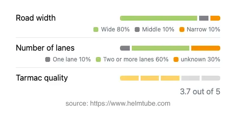
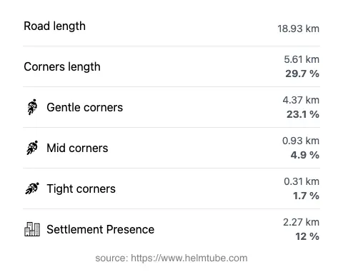
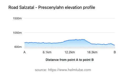
The Salzatal – Prescenylahn route covers approximately 18.9 km (11.7 miles), with elevations ranging from 660 m (2,165 ft) to 841 m (2,759 ft). The road surface is asphalt, with a quality rating that can be described as generally good, though some sections may show moderate wear. Riders will encounter a mix of road widths: the majority (about 80%) is wide enough for comfortable two-way traffic, while narrower and mid-width segments are present, particularly near settlements or where the road hugs the riverbank. The route is predominantly two lanes (about 60%), with a smaller proportion of single-lane stretches. The road is gently curved overall, making it suitable for riders seeking a relaxed journey rather than a highly technical ride. The proximity to the Salza River (53% of the route) adds to the riding experience, with the river’s course dictating the road’s gentle bends and occasional viewpoints.
Natural Features and Attractions Along the Route
One of the defining characteristics of the Salzatal – Prescenylahn route is its integration with the surrounding alpine environment. The road crosses or skirts several mountain ranges, including the Kräuterin and the Ybbstal Alps. The proximity to the Salza River is a notable feature, with the river renowned for its clear waters and popularity among kayakers and anglers. Viewpoints along the route provide opportunities to observe the river valley and the surrounding peaks. The nearby town of Mariazell is a significant attraction, known for its basilica and status as a pilgrimage site. The combination of river, mountains, and cultural sites makes this route appealing to riders interested in both natural and historical features.
Road Closures, Seasonal Access, and Practical Considerations
The Salzatal – Prescenylahn route is generally open to motorcyclists throughout the year. However, due to its alpine location and elevation, winter conditions can lead to temporary closures or hazardous surfaces, particularly after heavy snowfall or during periods of ice. Riders are advised to check local traffic updates before planning a trip, especially in late autumn, winter, and early spring. There are no known permanent restrictions for motorcycles on this route. Event-related closures are rare but may occur during local festivals or road maintenance. For up-to-date information on road conditions and closures in Austria, riders can consult the ASFINAG Traffic Information portal.
Tolls, Fees, and Additional Information
There are currently no tolls or entrance fees specifically for motorcycles on the Salzatal – Prescenylahn route. However, toll conditions in Austria may change, and some alpine roads in the region do require payment. Riders should verify current toll requirements before departure. Comprehensive information about tolls and vignettes for Austrian roads can be found on the ASFINAG Toll and Vignette website. It is recommended to check this resource for the latest updates on tolls and road fees applicable to motorcycles and other vehicles.
Explore the Region: Roads Close By
Discover more amazing roads located near the route featured in this article. The list below highlights nearby routes that are perfect for extending your ride or planning your next adventure.
Ride the Best: Austria’s Top Motorcycle Roads
These are the best motorbiking roads in Austria. The list below shows links to articles about top-rated motorcycle routes in the country. Explore the most popular roads in Austria and plan your next unforgettable motorbike adventure.