Exploring the Sedlo Učja Pass: A Motorcyclist’s Guide to the 401 Žaga-Učja Road
Locals know best!
If you travel this road often or live close by you will be given a chance to provide your valuable rating soon! Sign in and stay connected.Location and Access to the 401 Žaga-Učja Road
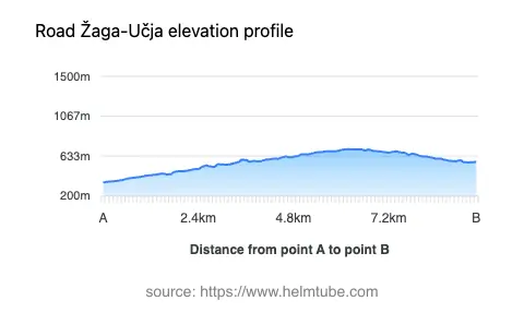
The 401 Žaga-Učja road is situated in northwestern Slovenia, within the Julian Alps, a subrange of the greater Alps. The route connects the Soča Valley near the settlement of Žaga to the Učja Valley, crossing the Sedlo Učja mountain pass at an elevation of 709 m (2,326 ft). The nearest major town is Bovec, located approximately 6.6 km (4.1 miles) from the starting point. The road’s position makes it a strategic link between Slovenia and the border with Italy, and it is often used by riders seeking an alternative to busier alpine passes. An interactive map showing the route can be found at the end of this article.
Road Characteristics and Riding Experience
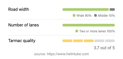
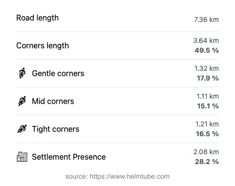
The 401 Žaga-Učja road extends for 7.4 km (4.6 miles), with an elevation range from 347 m (1,138 ft) to 708 m (2,323 ft). The route is classified as a mountain pass road, crossing the Sedlo Učja and forming part of the Julian Alps. The road is predominantly wide (about 92%), with a small section of medium width. It features two lanes for almost the entire length (about 96%), providing sufficient space for motorcycles and other vehicles. The surface is asphalt, rated as moderate to good in quality, which allows for a comfortable ride, though some sections may require caution due to occasional surface irregularities. The road is notably twisty, offering a series of engaging curves that appeal to experienced riders seeking a technical challenge. Approximately 28% of the route passes through inhabited areas, but the majority traverses forested and mountainous terrain, providing a sense of isolation and immersion in the alpine environment.
Mountain Pass and Surrounding Attractions
The highlight of the route is the crossing of Sedlo Učja, a lesser-known mountain pass that serves as a gateway between the Soča and Učja valleys. The pass itself is surrounded by the dramatic landscapes of the Julian Alps, with opportunities for panoramic views and access to hiking trails. The nearby town of Bovec is a popular base for outdoor activities, including whitewater rafting on the Soča River and hiking in Triglav National Park. The region is also known for its historical significance, with remnants from World War I and traditional alpine villages dotting the landscape. Riders may wish to explore these attractions before or after traversing the pass.
Practical Information: Closures, Tolls, and Regulations
The 401 Žaga-Učja road is generally open to motorcycles throughout the year, but temporary closures may occur due to adverse weather conditions, particularly in winter when snow or ice can make the pass impassable. There are no permanent restrictions on motorcycle access. No tolls or entrance fees are currently required to use this road, but riders should be aware that toll conditions may change in the future. For up-to-date information on road tolls and entrance fees in Slovenia, consult the official DARS website. The maximum speed limit on this route is 50 km/h (31 mph), and riders should exercise caution on the twisty sections, especially in wet or low-visibility conditions.
Planning Your Ride and Interactive Map
When planning a ride on the 401 Žaga-Učja road, it is advisable to check local weather forecasts and road conditions, particularly during the colder months. The route’s moderate surface quality and wide lanes make it suitable for most motorcycles, but less experienced riders should be prepared for the technical demands of the curves and elevation changes. The proximity to Bovec and the attractions of the Julian Alps provide ample opportunities for extended exploration. An interactive map of the 401 Žaga-Učja road is available below to assist with route planning and navigation.
Explore the Region: Roads Close By
Discover more amazing roads located near the route featured in this article. The list below highlights nearby routes that are perfect for extending your ride or planning your next adventure.
Ride the Best: Slovenia’s Top Motorcycle Roads
These are the best motorbiking roads in Slovenia. The list below shows links to articles about top-rated motorcycle routes in the country. Explore the most popular roads in Slovenia and plan your next unforgettable motorbike adventure.