Exploring the Sevnica–Radeče Road: A Technical Ride Through Slovenia’s Heartland
Locals know best!
If you travel this road often or live close by you will be given a chance to provide your valuable rating soon! Sign in and stay connected.Location and Overview of the Sevnica–Radeče Road
The Sevnica–Radeče road is situated in central Slovenia, linking the town of Sevnica to Radeče. The route traverses a predominantly rural landscape, passing through smaller settlements such as Polana and Lahov Graben. The road’s alignment follows the undulating terrain between the Sava River valley and the surrounding hills, offering a ride that is both engaging and accessible. An interactive map showing the exact route can be found at the end of this article.
Technical Details and Riding Experience
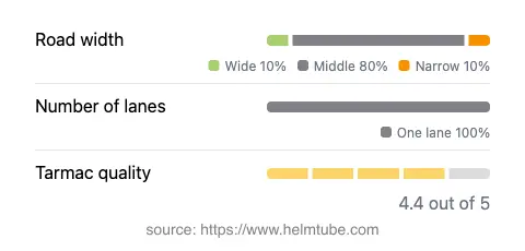
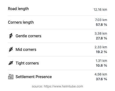
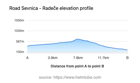
Spanning approximately 12.2 km (7.6 miles), the Sevnica–Radeče road is characterized by its gently curved alignment, making it suitable for riders who appreciate a moderate level of technical challenge. The road surface is asphalt and is generally rated as very good, providing a reliable grip for motorcycles. Most of the route consists of a single lane (about 90%), with the majority of the road being of medium width (about 76%), though there are sections that are notably narrow (15%) and a few that are wide (7%). The elevation ranges from 190 m (623 ft) at its lowest point to 667 m (2,188 ft) at its highest, offering some mild elevation changes without steep gradients. Approximately 38% of the road passes through inhabited areas, giving riders occasional glimpses of local life amid the rural scenery.
Points of Interest Along the Route
While the Sevnica–Radeče road is primarily valued for its riding characteristics, the towns at either end offer notable attractions. Sevnica Castle is a prominent landmark, perched above the town and offering panoramic views of the Sava River valley. In Radeče, visitors can explore the historic Radeče Paper Mill, which has played a significant role in the region’s industrial heritage. The route itself passes through the settlements of Polana and Lahov Graben, providing opportunities to experience the quieter side of Slovenian rural life. For those interested in extending their journey, the nearby Kostanjevica Monastery is within a reasonable riding distance.
Road Closures and Seasonal Considerations
The Sevnica–Radeče road is generally open to motorcycles year-round, with no regular seasonal closures reported. However, as with many rural roads in Slovenia, temporary closures may occur due to maintenance work, local events, or adverse weather conditions, particularly during periods of heavy rain or snow. Riders are advised to check local traffic updates before setting out, especially in winter months when road conditions can change rapidly. There are no known restrictions specifically affecting motorcycles on this route.
Tolls, Fees, and Practical Information
There are currently no tolls or entrance fees required to ride the Sevnica–Radeče road. The route is part of the local road network and is freely accessible to all vehicles, including motorcycles. Riders should be aware that toll conditions may change in the future, and it is advisable to consult the official DARS website for the most up-to-date information on road tolls and fees in Slovenia. Fuel stations and basic amenities are available in both Sevnica and Radeče, but services are limited along the route itself, so planning ahead is recommended.
Explore the Region: Roads Close By
Discover more amazing roads located near the route featured in this article. The list below highlights nearby routes that are perfect for extending your ride or planning your next adventure.
Ride the Best: Slovenia’s Top Motorcycle Roads
These are the best motorbiking roads in Slovenia. The list below shows links to articles about top-rated motorcycle routes in the country. Explore the most popular roads in Slovenia and plan your next unforgettable motorbike adventure.