Exploring the Slano–Zavala Road: A Technical Overview for Motorcyclists
Locals know best!
If you travel this road often or live close by you will be given a chance to provide your valuable rating soon! Sign in and stay connected.Location and Route Overview
The Slano–Zavala road is situated in southern Croatia, running inland from the Adriatic coast. It connects the village of Slano, located northwest of Dubrovnik, to the smaller settlement of Zavala. The route traverses a hilly landscape typical of the region, offering views of the surrounding countryside and glimpses of the Adriatic Sea. The road is positioned away from major urban centers, making it a quieter alternative to the busier coastal highways. An interactive map showing the precise route of the Slano–Zavala road can be found at the end of this article.
Road Characteristics and Riding Experience
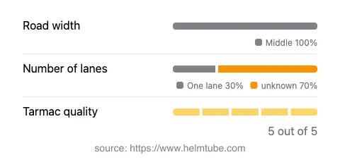
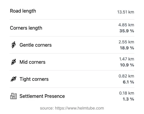
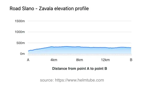
The Slano–Zavala road extends for approximately 13.5 km (8.4 miles), with an elevation range from 130 m (427 ft) to 340 m (1,115 ft). The surface is asphalt and is rated as excellent, providing a smooth ride throughout. The road is moderately curvy, with a layout that offers a mix of gentle bends and occasional tighter turns, but does not reach the complexity of mountain passes. The width is consistently in the middle range (about 100%), allowing comfortable passage for vehicles in both directions. Only a small portion (about 34%) is single-lane, and the route rarely passes through inhabited areas (approximately 1.3%), contributing to a relaxed riding environment. The combination of elevation changes and curves makes it suitable for riders seeking a balanced and enjoyable journey without excessive technical demands.
Viewpoints and Attractions Along the Route
One of the notable features of the Slano–Zavala road is its proximity to several viewpoints that offer expansive vistas of the Dalmatian hinterland and the Adriatic coastline. While the road itself does not pass directly through major tourist attractions, its elevated sections provide opportunities to stop and appreciate the landscape. The village of Slano, at the starting point, is known for its sheltered bay and historical sites, including the Franciscan Monastery. Zavala, at the other end, is a quiet settlement that serves as a gateway to rural areas and hiking trails. Riders interested in exploring further can use this road as a link to less-traveled parts of the Dubrovnik-Neretva County.
Road Closures, Seasonal Access, and Regulations
There are currently no known restrictions or closures for motorcycles on the Slano–Zavala road. The region experiences a Mediterranean climate, and the road remains accessible throughout the year. However, during periods of heavy rain or rare winter conditions, localized disruptions may occur, particularly in higher sections. There are no regular event-related closures reported. Riders are advised to check local traffic updates before departure, especially during adverse weather conditions.
Tolls, Fees, and Practical Information
The Slano–Zavala road does not have any tolls or entrance fees for motorcycles or other vehicles. It is a public road maintained by local authorities. Riders should note that toll conditions in Croatia may change in the future, and it is advisable to consult official resources for the most up-to-date information. For details on road tolls and regulations in Croatia, visit the Hrvatske autoceste website. Fuel stations and services are available in Slano, but options are limited along the route itself, so planning ahead is recommended.
Explore the Region: Roads Close By
Discover more amazing roads located near the route featured in this article. The list below highlights nearby routes that are perfect for extending your ride or planning your next adventure.
Ride the Best: Croatia’s Top Motorcycle Roads
These are the best motorbiking roads in Croatia. The list below shows links to articles about top-rated motorcycle routes in the country. Explore the most popular roads in Croatia and plan your next unforgettable motorbike adventure.