Exploring the Slovenj Gradec–Šoštanj Alpine Route: A Motorcyclist’s Guide
Locals know best!
If you travel this road often or live close by you will be given a chance to provide your valuable rating soon! Sign in and stay connected.Location and Overview of the Slovenj Gradec–Šoštanj Alpine Route
The Slovenj Gradec–Šoštanj Alpine Route is situated in northern Slovenia, linking the town of Slovenj Gradec with Šoštanj. The road crosses the eastern fringes of the Alps, specifically intersecting the Alps and the Karavanke mountain ranges. This region is characterized by a blend of forested hills, alpine meadows, and small settlements, making it a notable corridor for those seeking to experience Slovenia’s mountainous landscapes. An interactive map showing the route is available at the end of this article.
Road Characteristics and Riding Experience
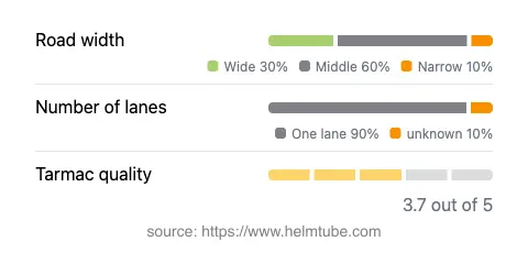
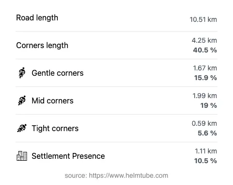
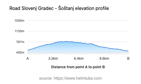
The Slovenj Gradec–Šoštanj Alpine Route extends for approximately 10.5 km (6.5 miles), with elevations ranging from 452 m (1,483 ft) to 784 m (2,572 ft). The road is predominantly surfaced with asphalt of moderate quality, offering a generally comfortable ride with some sections that may require increased attention due to surface wear. The route is moderately twisty, providing a mix of gently curved and more pronounced bends, suitable for riders who appreciate a varied riding rhythm without the intensity of extreme switchbacks. Most of the road consists of one lane (about 90%), with a small proportion featuring two lanes. The width varies, with the majority being of medium width (about 60%), and some stretches classified as wide or narrow. Only a minor portion of the route passes through inhabited areas, allowing for an uninterrupted riding experience through natural surroundings.
Points of Interest Along the Route
While the road itself is the main attraction for motorcyclists, the towns at either end offer cultural and historical interest. Slovenj Gradec is known for its medieval old town and the Koroška Regional Museum, while Šoštanj is notable for its industrial heritage and proximity to the Velenje Lake. The surrounding alpine landscape provides opportunities for hiking and nature observation, with the Karavanke range offering additional exploration for those interested in extending their journey.
Seasonal Accessibility and Road Closures
The Slovenj Gradec–Šoštanj Alpine Route is generally open to motorcycles throughout the year. However, due to its elevation and alpine location, temporary closures can occur during winter months or periods of adverse weather, particularly due to snow or ice. There are no permanent restrictions for motorcycles, but riders should consult local traffic information before departure, especially in late autumn and early spring when conditions can change rapidly. Event-related closures are rare but may occur during local festivals or road maintenance operations.
Tolls, Fees, and Practical Information
Currently, there are no tolls or entrance fees required for motorcycles on the Slovenj Gradec–Šoštanj Alpine Route. Riders should be aware that toll conditions may change in the future, and it is advisable to verify the latest information before traveling. For up-to-date details on road tolls and fees in Slovenia, refer to the official DARS website. Standard speed limits apply, with most sections limited to 90 km/h (56 mph) outside inhabited areas and reduced limits within towns. Fuel and basic services are available in both Slovenj Gradec and Šoštanj, making this route accessible for both local and touring motorcyclists.
Explore the Region: Roads Close By
Discover more amazing roads located near the route featured in this article. The list below highlights nearby routes that are perfect for extending your ride or planning your next adventure.
Ride the Best: Slovenia’s Top Motorcycle Roads
These are the best motorbiking roads in Slovenia. The list below shows links to articles about top-rated motorcycle routes in the country. Explore the most popular roads in Slovenia and plan your next unforgettable motorbike adventure.