Exploring the Slovenska Bistrica–Slovenske Konjice Mountain Route: A Motorcyclist’s Guide
Locals know best!
If you travel this road often or live close by you will be given a chance to provide your valuable rating soon! Sign in and stay connected.Location and Geographic Context
The Slovenska Bistrica–Slovenske Konjice route is situated in northeastern Slovenia, bridging the towns of Slovenska Bistrica and Slovenske Konjice. The road traverses the lower elevations of the Alps and the Karawanken und Bachergebirge, providing a transition between two significant Slovenian regions. The area is characterized by rolling hills, forested slopes, and agricultural land, with the route serving as a connector between local communities and as an access point to the broader alpine landscape. An interactive map showing the road can be found at the end of the article.
Road Characteristics and Riding Experience
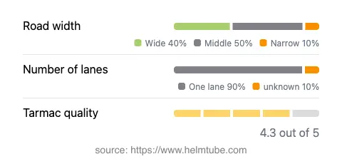
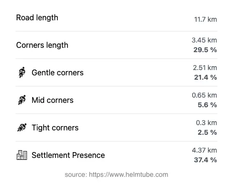
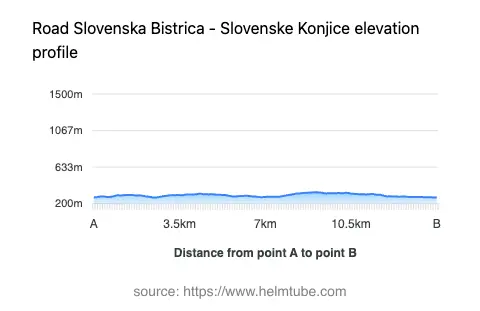
The road between Slovenska Bistrica and Slovenske Konjice extends for approximately 11.7 km (7.3 miles), with elevations ranging from 273 m (896 ft) to 335 m (1,099 ft). The surface is asphalt and is generally rated as very good, offering a smooth ride for most of its length. The route is moderately curvy, providing a mix of gently curved and straight sections, suitable for riders seeking a relaxed mountain experience rather than a highly technical challenge. The majority of the road features a single lane in each direction (about 95%), with the width varying: middle-width sections dominate (about 51%), while wide stretches account for about 33% and narrow segments for 10%. Approximately 37% of the route passes through inhabited areas, including the settlements of Ličenca, Industrijska ulica, and Videž. The maximum speed limit is 50 km/h (31 mph), reflecting the road’s passage through populated zones and its mountain setting.
Mountain Ranges and Local Attractions
This road crosses the foothills of the Alps and the Karawanken und Bachergebirge. While the route itself does not reach high alpine passes, it provides access to the surrounding mountain landscapes and serves as a gateway to outdoor activities such as hiking and cycling. The nearby town of Slovenska Bistrica is home to Slovenska Bistrica Castle, a notable historical site, while Slovenske Konjice is known for its wine-growing tradition and the Žiče Charterhouse, a medieval monastery located a short distance from the town. These attractions make the route appealing not only for its riding qualities but also for its cultural and historical context.
Road Closures and Seasonal Considerations
There are no known permanent closures for motorcycles on the Slovenska Bistrica–Slovenske Konjice route. The road remains open throughout the year, although temporary closures may occur due to roadworks, local events, or adverse weather conditions, particularly in winter when snow or ice can affect mountain roads in Slovenia. Riders are advised to check local traffic updates before planning their journey, especially during the colder months.
Tolls, Fees, and Practical Information
Currently, there are no tolls or entrance fees required to ride the Slovenska Bistrica–Slovenske Konjice route. However, toll conditions may change in the future, and it is recommended to consult the official Slovenian motorway and toll information page for the most up-to-date details: DARS. The road is maintained to a high standard, but as with all mountain routes, riders should remain vigilant for changing weather and surface conditions.
Explore the Region: Roads Close By
Discover more amazing roads located near the route featured in this article. The list below highlights nearby routes that are perfect for extending your ride or planning your next adventure.
Ride the Best: Slovenia’s Top Motorcycle Roads
These are the best motorbiking roads in Slovenia. The list below shows links to articles about top-rated motorcycle routes in the country. Explore the most popular roads in Slovenia and plan your next unforgettable motorbike adventure.