Riding the Šoštanj–Mežica Route: Through the Karawanken-Karavanke UNESCO Global Geopark
Locals know best!
If you travel this road often or live close by you will be given a chance to provide your valuable rating soon! Sign in and stay connected.Location and Overview of the Šoštanj–Mežica Route
The Šoštanj–Mežica road is situated in northern Slovenia, connecting the towns of Šoštanj and Mežica. The route passes through the settlements of Koroška cesta and Zavodnje, and is positioned within the Karawanken-Karavanke UNESCO Global Geopark. The road’s alignment takes riders across the Alps and the Karavanke mountain range, offering a transition from lower elevations near Šoštanj to higher alpine terrain before descending towards Mežica. An interactive map showing the route is available at the end of this article.
Road Characteristics and Riding Experience
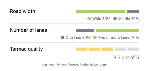
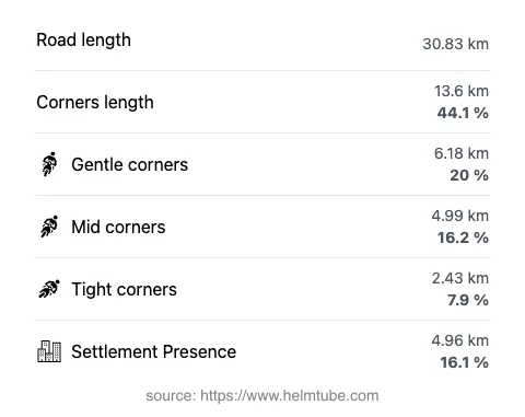
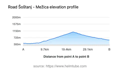
This road covers a distance of approximately 30.8 km (19.1 miles), with an elevation range from 353 m (1,158 ft) to 1,082 m (3,550 ft). The surface is asphalt, with a quality rated as moderate—generally reliable but with some sections that may require caution, especially after adverse weather. The route is moderately curvy, providing a mix of gently winding and more technical segments, suitable for riders who appreciate a varied riding rhythm. Most of the road is wide (about 76%), with the remainder being of medium width (22%) and only a small portion classified as narrow (1%). The majority of the route features two lanes (about 65%), while the rest alternates between single-lane stretches and wider sections. Inhabited areas account for roughly 16% of the journey, with the remainder traversing forested and mountainous landscapes.
Natural Features and Points of Interest
The Šoštanj–Mežica road is notable for its passage through the Karawanken-Karavanke UNESCO Global Geopark, an area recognized for its geological diversity and alpine scenery. The route skirts the Petzen/Peca massif and crosses both the Alps and the Karavanke range, providing access to panoramic views and unique geological formations. Near Šoštanj, the road passes close to Družmirsko jezero, a lake formed by subsidence due to mining activities, which is now a local landmark. The towns at each end—Šoštanj, known for its energy industry and historic architecture, and Mežica, famous for its mining heritage—offer opportunities for cultural exploration and rest stops. The region’s alpine environment is also home to hiking trails and viewpoints, making it a suitable base for further outdoor activities.
Speed Limits, Seasonal Closures, and Accessibility
Speed limits along the Šoštanj–Mežica route are typically set at 50 km/h (31 mph) and 30 km/h (19 mph) in certain sections, particularly near settlements and tighter curves. The road remains open to motorcycles throughout the year, but winter conditions—especially at higher elevations—can lead to temporary closures or hazardous riding surfaces due to snow and ice. Riders are advised to check local weather forecasts and municipal updates before planning a winter journey. There are no known event-related closures affecting this route on a regular basis.
Tolls, Fees, and Further Information
Currently, there are no tolls or entrance fees required for motorcycles on the Šoštanj–Mežica road. However, toll conditions may change in the future, and riders should consult official resources for the most up-to-date information. For details on road tolls and vignettes in Slovenia, visit the DARS Motorway Company website. As the route passes through a UNESCO Global Geopark, riders are encouraged to respect local regulations and environmental guidelines to preserve the area’s natural and cultural heritage.
Explore the Region: Roads Close By
Discover more amazing roads located near the route featured in this article. The list below highlights nearby routes that are perfect for extending your ride or planning your next adventure.
Ride the Best: Slovenia’s Top Motorcycle Roads
These are the best motorbiking roads in Slovenia. The list below shows links to articles about top-rated motorcycle routes in the country. Explore the most popular roads in Slovenia and plan your next unforgettable motorbike adventure.