Exploring the Stavča vas – Kočevske Poljane Road: A Technical Overview for Motorcyclists
Locals know best!
If you travel this road often or live close by you will be given a chance to provide your valuable rating soon! Sign in and stay connected.Location and Geographic Context
The Stavča vas – Kočevske Poljane road is situated in southeastern Slovenia, connecting two small villages: Stavča vas and Kočevske Poljane. The route lies within the Lower Carniola region, an area characterized by rolling hills, agricultural land, and proximity to the Krka River. The road’s alignment places it near the river for nearly half its length, offering views of the waterway and the surrounding countryside. This corridor is not a major arterial route but serves as a connector between local settlements and provides access to the rural heartland of the region. An interactive map showing the precise route of the road can be found at the end of this article.
Road Characteristics and Riding Experience
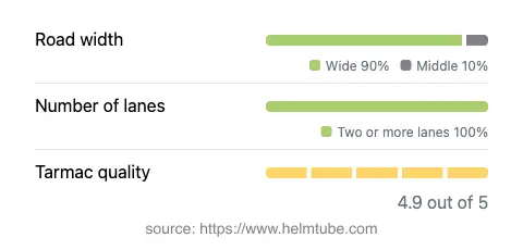
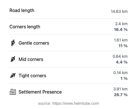
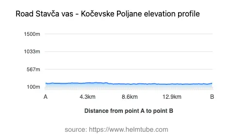
The Stavča vas – Kočevske Poljane road extends for approximately 14.6 km (9.1 miles), with the majority of its surface rated as excellent quality asphalt. The road is predominantly wide (about 90%), with a small proportion classified as of medium width. There are two lanes throughout nearly the entire route, ensuring consistent traffic flow and overtaking opportunities. The road is gently curved, making it suitable for riders who prefer a relaxed pace over technical cornering. Elevation varies modestly, ranging from 173 m (568 ft) at its lowest point to 219 m (719 ft) at its highest, resulting in minimal altitude-related challenges. The maximum speed limits along the route are 50 km/h (31 mph), 60 km/h (37 mph), and 90 km/h (56 mph), depending on the specific segment and proximity to inhabited areas. Approximately 27% of the road passes through villages or developed zones, while the remainder traverses open countryside.
Natural Features and Points of Interest
A defining feature of this road is its adjacency to the Krka River, one of Slovenia’s notable waterways. The Krka River is known for its clean waters, karst springs, and historical significance in the region. While the road itself does not pass through major tourist destinations, it provides access to the rural landscapes and riverine environments typical of Lower Carniola. Riders may consider brief stops in the villages of Stavča vas and Kočevske Poljane to experience local culture and hospitality. The area is also within reach of Krka National Park, which, while not directly on the route, is a significant natural attraction in the broader region.
Road Access, Closures, and Fees
There are currently no known restrictions or seasonal closures affecting motorcycle access on the Stavča vas – Kočevske Poljane road. The route remains open year-round, with no documented event-related closures. There are no tolls or entrance fees required to use this road. However, toll conditions and access regulations may change in the future. For the most up-to-date information on road tolls and entrance fees in Slovenia, consult the official DARS vignette information page.
Practical Considerations for Motorcyclists
Given its excellent surface quality and wide lanes, the Stavča vas – Kočevske Poljane road is suitable for riders of all experience levels. The gentle curves and moderate speed limits make it an accessible option for those seeking a relaxed ride through rural Slovenia. Services such as fuel stations and restaurants are limited along the route itself, so riders are advised to plan accordingly. The proximity to the Krka River offers opportunities for brief detours or rest stops along the water. For those interested in exploring the broader region, the road can serve as a connector to other local routes and attractions. An interactive map of the route is available at the end of this article for further planning.
Explore the Region: Roads Close By
Discover more amazing roads located near the route featured in this article. The list below highlights nearby routes that are perfect for extending your ride or planning your next adventure.
Ride the Best: Slovenia’s Top Motorcycle Roads
These are the best motorbiking roads in Slovenia. The list below shows links to articles about top-rated motorcycle routes in the country. Explore the most popular roads in Slovenia and plan your next unforgettable motorbike adventure.