Exploring the Trilj Hinterland: Riding the Lokalna cesta 67049 in Croatia
Locals know best!
If you travel this road often or live close by you will be given a chance to provide your valuable rating soon! Sign in and stay connected.Location and Access to Lokalna cesta 67049
Lokalna cesta 67049 is situated in the inland region of Dalmatia, Croatia, with both its starting and ending points located near the town of Trilj. The road traverses a rural area characterized by rolling hills and agricultural land, lying approximately 8 km (5 miles) from the center of Trilj at its furthest point. The region is known for its proximity to the Cetina River and the archaeological site of Tilurium, a Roman military camp. Riders can access the road from Trilj, which serves as a convenient base for exploring the surrounding countryside. An interactive map showing the route of Lokalna cesta 67049 can be found at the end of this article.
Road Characteristics and Riding Experience
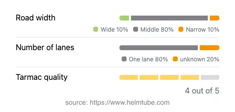
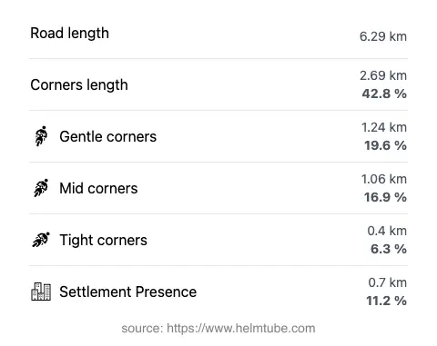
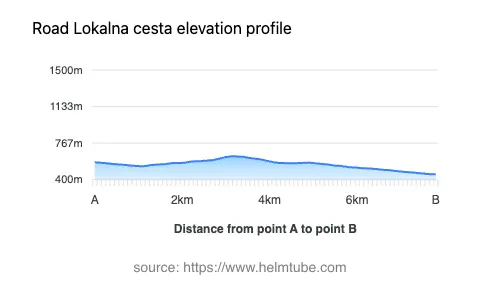
Lokalna cesta 67049 extends for approximately 6.3 km (3.9 miles), offering a moderately curvy ride that will appeal to those who enjoy a mix of gentle bends and straight sections. The road surface is asphalt and is generally in good condition, with a quality rating of four out of five. Most of the route is of medium width (about 78%), with some narrower sections (15%) and a few wider stretches (5%). The majority of the road is single-lane, making up roughly four-fifths of its length. Riders should be prepared for occasional oncoming traffic, especially in the narrower segments. The elevation ranges from 454 m (1,490 ft) to 636 m (2,087 ft), providing subtle but noticeable changes in altitude throughout the ride. Only a small portion of the road (about 11%) passes through inhabited areas, so expect a predominantly rural environment.
Points of Interest and Attractions Nearby
While Lokalna cesta 67049 itself is primarily a connector through the countryside, the nearby town of Trilj offers several attractions worth visiting. The Tilurium archaeological site, located just outside Trilj, is a significant Roman ruin that provides insight into the area's ancient history. The Cetina River is also nearby, popular for rafting and outdoor activities. For those interested in local culture, the Trilj Museum showcases artifacts from the region's past. These attractions make the area a worthwhile stop for motorcyclists seeking more than just a riding experience.
Road Closures, Seasonal Considerations, and Regulations
Lokalna cesta 67049 is a public road and is generally open to motorcycles year-round. There are no known seasonal closures specific to this route, and it is not subject to winter closure, although riders should be aware that weather conditions in inland Dalmatia can vary, especially during the colder months. Occasional maintenance or local events may result in temporary closures, so it is advisable to check with local authorities or the Croatian Automobile Club (HAK) for up-to-date information before planning your ride. The maximum speed limit on this road is 50 km/h (31 mph), and standard Croatian traffic regulations apply.
Tolls, Fees, and Practical Information
There are currently no tolls or entrance fees required to ride Lokalna cesta 67049. The road is part of the local public road network and is free to access for all vehicles, including motorcycles. However, toll conditions in Croatia may change in the future, so it is recommended to consult the Croatian Automobile Club (HAK) toll rates page for the latest information on road charges throughout the country. Fuel and basic services are available in Trilj, making it a practical starting or ending point for your journey.
Explore the Region: Roads Close By
Discover more amazing roads located near the route featured in this article. The list below highlights nearby routes that are perfect for extending your ride or planning your next adventure.
Ride the Best: Croatia’s Top Motorcycle Roads
These are the best motorbiking roads in Croatia. The list below shows links to articles about top-rated motorcycle routes in the country. Explore the most popular roads in Croatia and plan your next unforgettable motorbike adventure.