Exploring the Velebit Mountain Road: A Motorcyclist’s Guide Through Croatia’s Wild Heart
Locals know best!
If you travel this road often or live close by you will be given a chance to provide your valuable rating soon! Sign in and stay connected.Location and Geographic Context
Lokalna cesta 59148, commonly referred to as the Velebit Mountain Road among local riders, is situated in the northern section of Croatia’s Velebit mountain range. The route lies within the boundaries of two major protected areas: Velebit Nature Park and Northern Velebit National Park. The road’s alignment follows the undulating terrain of the Velebit massif, offering access to some of the most remote and pristine environments in Croatia. The absence of significant settlements at either end of the road underscores its isolation and appeal for those seeking a ride away from urban centers. An interactive map showing the road’s course is available at the end of this article.
Road Characteristics and Riding Experience
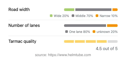
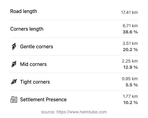
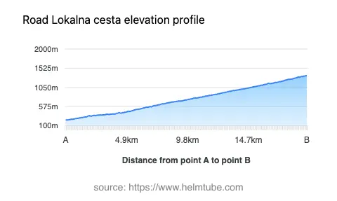
The Velebit Mountain Road extends for approximately 17.4 km (10.8 miles), with elevations ranging from 240 m (787 ft) to 1,346 m (4,416 ft). The road is surfaced with asphalt of high quality, generally rated as excellent by local standards. Riders will encounter a route that is moderately curvy, with a mix of gently winding sections and occasional tighter bends, making it suitable for both experienced and intermediate motorcyclists. The majority of the road is of medium width (about 63%), with narrower stretches (16%) and some wider segments (15%). Most of the route is single-lane (about 82%), with only a small portion offering two lanes (3%). The road passes through predominantly uninhabited terrain, with only about 10% traversing areas near human habitation. The combination of elevation, road quality, and minimal traffic creates a riding environment that is both engaging and relatively safe, provided that riders remain alert to changing weather and wildlife crossings.
Natural Attractions and Viewpoints
One of the defining features of the Velebit Mountain Road is its proximity to several notable viewpoints. These vantage points offer expansive views over the Adriatic Sea, the rugged Velebit peaks, and the forests of the national parks. While the road itself does not pass directly through any major settlements, it provides access to the heart of Velebit Nature Park and the protected landscapes of Northern Velebit National Park. Riders are encouraged to stop at the designated viewpoints to appreciate the unique karst formations and the biodiversity of the region. The area is also known for its hiking trails, such as the famous Premužić Trail, which can be accessed from points along the road. For those interested in Croatia’s natural heritage, this route offers a direct connection to some of the country’s most significant conservation areas.
Seasonal Accessibility and Road Closures
The Velebit Mountain Road is subject to seasonal closures, particularly during the winter months when snow and ice can make the route impassable. Motorcyclists should be aware that access may be restricted from late autumn through early spring, depending on weather conditions. There are no permanent closures for motorcycles, but temporary restrictions may be imposed due to maintenance work or adverse weather events. It is advisable to consult the official websites of Velebit Nature Park or Northern Velebit National Park for up-to-date information on road conditions and closures before planning a trip.
Tolls, Fees, and Practical Information
Currently, there is no dedicated road toll for using Lokalna cesta 59148. However, since the road passes through protected areas, entrance fees may apply for access to certain sections of the national parks, particularly if riders wish to stop and explore park facilities or hiking trails. These fees are subject to change, and it is recommended to verify the latest information on the official Croatia road tolls and entrance fees page. Riders should also be prepared for variable weather conditions, especially at higher elevations, and ensure that their motorcycles are equipped for mountain riding. Fuel and services are limited along the route, so planning ahead is essential for a safe and enjoyable journey.
Explore the Region: Roads Close By
Discover more amazing roads located near the route featured in this article. The list below highlights nearby routes that are perfect for extending your ride or planning your next adventure.
Ride the Best: Croatia’s Top Motorcycle Roads
These are the best motorbiking roads in Croatia. The list below shows links to articles about top-rated motorcycle routes in the country. Explore the most popular roads in Croatia and plan your next unforgettable motorbike adventure.