Exploring the Višnja Gora – Zafara Route: A Motorcyclist’s Guide
Locals know best!
If you travel this road often or live close by you will be given a chance to provide your valuable rating soon! Sign in and stay connected.Location and Overview of the Višnja Gora – Zafara Road
The Višnja Gora – Zafara road is situated in central Slovenia, connecting the historic town of Višnja Gora with the village of Zafara. The route traverses the Lower Carniola region, an area known for its rolling hills and proximity to the Krka River. The road passes through the settlement of Grajski trg and is characterized by a mix of rural and semi-urban landscapes. An interactive map showing the exact route can be found at the end of this article.
Road Characteristics and Riding Experience
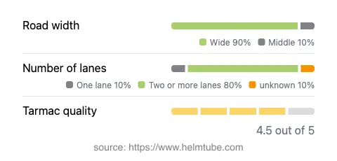
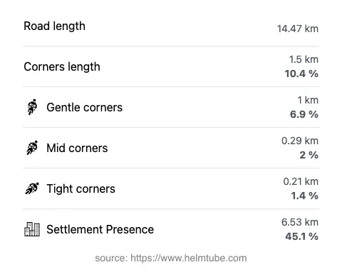
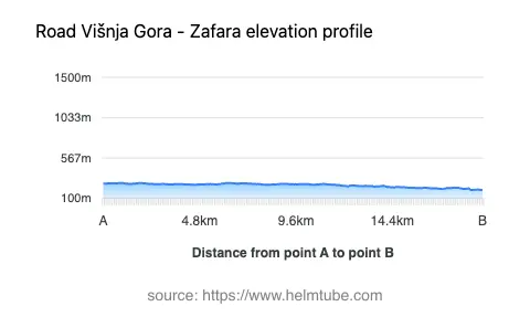
The Višnja Gora – Zafara road extends for approximately 14.5 km (9 miles), with the majority of its surface covered in high-quality asphalt. Riders will find the road to be gently curved, making it suitable for both novice and experienced motorcyclists. The surface quality is rated as very good, providing a comfortable and predictable ride. Most of the route consists of two lanes (about 81%), with the remainder being single-lane sections. The road is predominantly wide (about 84%), allowing for easy overtaking and maneuvering. Elevation changes are minimal, ranging from 196 m (643 ft) to 279 m (915 ft), ensuring a relaxed ride without significant climbs or descents. The maximum speed limits along the route are 50 km/h (31 mph) and 40 km/h (25 mph) in certain sections, reflecting the mix of inhabited and rural areas.
Following the Krka River: Natural and Cultural Highlights
A defining feature of this road is its close proximity to the Krka River, with approximately 86% of the route running alongside its banks. The Krka is a notable tributary of the Sava River and is recognized for its clear waters and picturesque surroundings. Riders can enjoy views of the river and the surrounding countryside, with opportunities to stop and explore local points of interest. The town of Višnja Gora, known for its medieval heritage and castle ruins, serves as a gateway to the route. The settlement of Grajski trg, whose name translates to 'Castle Square,' hints at the area's historical significance. The village of Zafara marks the end of the journey, offering a glimpse into rural Slovenian life. For those interested in extending their visit, the broader region features attractions such as the Lower Carniola wine routes and traditional inns.
Practical Information: Closures, Tolls, and Regulations
The Višnja Gora – Zafara road is open to motorcycles year-round, with no regular seasonal closures reported. Temporary closures may occur due to maintenance or local events, so it is advisable to check with the Slovenian Traffic Information Center before planning your ride. There are currently no tolls or entrance fees required for motorcycles on this route. However, toll conditions may change in the future. For up-to-date information on road tolls and entrance fees in Slovenia, consult the DARS Vignette Information page. Standard traffic regulations apply, including adherence to posted speed limits and the use of appropriate safety gear.
Planning Your Ride and Interactive Map
When planning a ride along the Višnja Gora – Zafara road, consider the mix of inhabited and rural sections, as approximately 45% of the route passes through populated areas. Fuel and basic amenities are available in Višnja Gora, while services in Zafara and along the route may be limited. The road’s gentle curves and wide lanes make it accessible for group rides and less experienced motorcyclists. For navigation and route planning, an interactive map is provided below to assist in visualizing the journey and identifying key waypoints.
Explore the Region: Roads Close By
Discover more amazing roads located near the route featured in this article. The list below highlights nearby routes that are perfect for extending your ride or planning your next adventure.
Ride the Best: Slovenia’s Top Motorcycle Roads
These are the best motorbiking roads in Slovenia. The list below shows links to articles about top-rated motorcycle routes in the country. Explore the most popular roads in Slovenia and plan your next unforgettable motorbike adventure.