Exploring the Vrgorac–Ljubuški Route: A Technical Overview for Motorcyclists
Locals know best!
If you travel this road often or live close by you will be given a chance to provide your valuable rating soon! Sign in and stay connected.Location and Regional Context
The Vrgorac–Ljubuški road is situated in southern Croatia, linking the town of Vrgorac with the border area near Ljubuški. The route passes through the settlement of Anđelići and traverses a predominantly rural landscape characterized by gentle hills and agricultural land. Vrgorac, located approximately 5.5 km (3.4 miles) from the road's starting point, is known for its historical significance and proximity to the Biokovo mountain range. The road's endpoint is near Ljubuški, a town in neighboring Bosnia and Herzegovina, situated about 7.2 km (4.5 miles) from the border crossing. An interactive map showing the road can be found at the end of the article.
Road Characteristics and Riding Experience
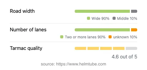
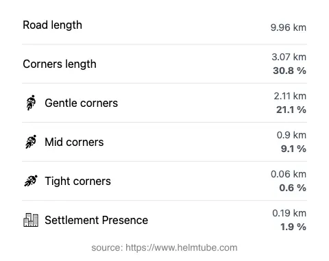
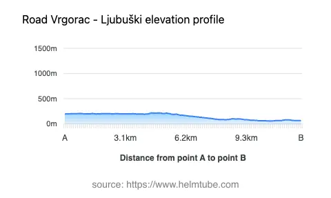
The Vrgorac–Ljubuški route extends for approximately 10 km (6.2 miles), offering a ride that is gently curved rather than highly twisty. The road surface is asphalt and is generally rated as very good, providing a smooth and predictable riding experience. The majority of the route (about 90%) consists of two wide lanes, allowing for comfortable passage and safe overtaking where permitted. The road width is predominantly wide (about 91%), with only a small portion classified as middle width. Inhabited areas are minimal along the route, with less than 2% of the road passing through settlements, contributing to a largely uninterrupted ride. Elevation ranges from 59 m (194 ft) to 220 m (722 ft), resulting in mild elevation changes that do not present significant challenges for most riders.
Traffic Regulations, Speed Limits, and Safety
The maximum speed limit on the Vrgorac–Ljubuški road is 50 km/h (31 mph), reflecting the road's function as a connector between towns and its proximity to border controls. Riders should be aware of local traffic regulations, especially near inhabited areas and the border crossing. The road's surface quality is rated as excellent, minimizing the risk of unexpected hazards. However, as with all border-adjacent routes, increased vigilance is recommended due to potential changes in traffic patterns and the presence of customs or police checks. The route is not known for heavy traffic, but seasonal variations may occur, particularly during holiday periods or local events.
Road Closures, Tolls, and Practical Considerations
There are currently no known restrictions or closures for motorcycles on the Vrgorac–Ljubuški road. The route remains open year-round, with no regular seasonal closures reported. Event-related closures are rare but may occur in the case of local festivities or maintenance work. As of the latest available information, there are no tolls or entrance fees required to use this road. Riders should note that toll conditions may change in the future, and it is advisable to consult the Hrvatske autoceste website for the most up-to-date information on road tolls and entrance fees in Croatia.
Nearby Attractions and Points of Interest
While the Vrgorac–Ljubuški road itself is primarily a connector, the surrounding region offers several attractions worth exploring. Vrgorac is notable for its historic old town and proximity to the Biokovo mountain, a popular destination for outdoor enthusiasts. On the Bosnian side, Ljubuški is known for the Kravica Waterfall, a natural landmark attracting visitors from across the region. These sites provide opportunities for riders to extend their journey and experience the cultural and natural highlights of the area.
Explore the Region: Roads Close By
Discover more amazing roads located near the route featured in this article. The list below highlights nearby routes that are perfect for extending your ride or planning your next adventure.
Ride the Best: Croatia’s Top Motorcycle Roads
These are the best motorbiking roads in Croatia. The list below shows links to articles about top-rated motorcycle routes in the country. Explore the most popular roads in Croatia and plan your next unforgettable motorbike adventure.