Exploring the Vrhnika–Žiri Road: A Technical Overview for Motorcyclists
Locals know best!
If you travel this road often or live close by you will be given a chance to provide your valuable rating soon! Sign in and stay connected.Location and General Overview
The Vrhnika–Žiri road is situated in central Slovenia, linking the town of Vrhnika to Žiri. The route passes through the settlement of Smrečje and traverses a region characterized by rolling hills and forested areas. This corridor serves as a connector between the Ljubljana Basin and the Poljane Valley, making it a practical choice for riders seeking to explore the less trafficked interior of Slovenia. An interactive map showing the road can be found at the end of the article.
Road Characteristics and Riding Experience
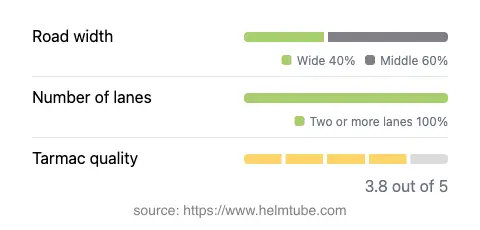
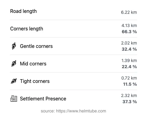
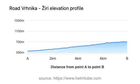
The Vrhnika–Žiri road extends for approximately 6.2 km (3.9 miles), with an elevation range from 354 m (1,161 ft) to 708 m (2,323 ft). The road is surfaced with asphalt of moderate quality, generally rated as fair to good. Riders will encounter a moderately twisty alignment, offering a mix of gently curved and sharper bends, suitable for those who appreciate a dynamic but not overly demanding ride. The road maintains two lanes throughout its length (about 100%), with the majority being of medium width (about 57%) and a significant portion classified as wide (35%). Narrow sections are virtually absent. About 37% of the route passes through inhabited areas, providing occasional glimpses of rural Slovenian life.
Tourist Attractions and Points of Interest
One of the notable features along this road is its proximity to local viewpoints, offering riders opportunities to pause and take in the surrounding landscape. While the route itself does not pass directly by major tourist attractions, the nearby settlement of Smrečje and the towns of Vrhnika and Žiri provide access to regional points of interest. Vrhnika is known for its historical significance and natural sites, such as the Technical Museum of Slovenia in Bistra, while Žiri is recognized for its traditional lace-making heritage. The road's alignment through hilly terrain also means that several unofficial viewpoints can be found along the way, offering panoramic vistas of the Slovenian countryside.
Road Closures and Seasonal Considerations
There are no permanent closures for motorcycles on the Vrhnika–Žiri road. However, as with many rural roads in Slovenia, temporary closures may occur due to maintenance work, local events, or adverse weather conditions, particularly during winter months when snow and ice can make the route hazardous. Riders are advised to check local traffic updates before departure, especially in the colder season.
Tolls, Fees, and Additional Information
The Vrhnika–Žiri road does not currently require the payment of a toll or entrance fee for motorcycles. Riders should note that toll conditions may change in the future, and it is advisable to consult the official DARS website for the most up-to-date information regarding road charges in Slovenia. The route is generally open year-round, but weather-related disruptions are possible, particularly in winter.
Explore the Region: Roads Close By
Discover more amazing roads located near the route featured in this article. The list below highlights nearby routes that are perfect for extending your ride or planning your next adventure.
Ride the Best: Slovenia’s Top Motorcycle Roads
These are the best motorbiking roads in Slovenia. The list below shows links to articles about top-rated motorcycle routes in the country. Explore the most popular roads in Slovenia and plan your next unforgettable motorbike adventure.