Exploring the Vrlika Plateau Route: A Motorcyclist’s Guide to Županijska cesta 6082
Locals know best!
If you travel this road often or live close by you will be given a chance to provide your valuable rating soon! Sign in and stay connected.Location and Setting of Županijska cesta 6082
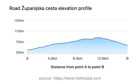
Županijska cesta 6082 is situated in the Dalmatian hinterland of Croatia, specifically in the vicinity of the town of Vrlika. The road connects several local streets, including 30. svibnja, Hrvoja Vukčića Hrvatinića, Ulica dr. Aloisa Mocka, and Trg fra Filipa Grabovca, forming a loop that both starts and ends near Vrlika. The surrounding area is characterized by a mix of rural settlements and open landscapes, with the road itself lying at elevations ranging from 397 m (1,302 ft) to 861 m (2,825 ft). An interactive map showing the route of Županijska cesta 6082 can be found at the end of this article.
Road Characteristics and Riding Experience
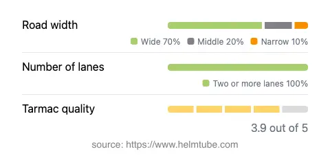
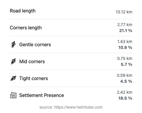
The route covers a total length of 13.1 km (8.1 miles), making it suitable for a short ride or as part of a longer regional tour. The road is moderately curvy, offering a riding experience that is neither monotonous nor overly demanding. Surface quality is generally good, with asphalt paving that rates as above average for the region. Most of the route consists of two lanes (about 90%), and the width varies, with the majority being wide (about 90%), interspersed with some middle and narrow sections. Approximately 18.5% of the road passes through inhabited areas, providing occasional opportunities for stops in local settlements. The elevation changes are gradual, with the highest point reaching 861 m (2,825 ft), offering occasional views of the surrounding plateau and nearby mountains.
Speed Limits, Traffic, and Seasonal Considerations
Speed limits along Županijska cesta 6082 vary between 30 km/h (19 mph), 40 km/h (25 mph), 50 km/h (31 mph), and 60 km/h (37 mph), depending on the proximity to settlements and road conditions. The road is open to motorcycles throughout the year, with no regular seasonal closures reported. However, riders should be aware that winter conditions can occasionally affect higher elevations, potentially leading to temporary restrictions due to snow or ice. There are no known event-related closures, but it is advisable to check local sources for any updates before planning a ride.
Tolls, Fees, and Practical Information
There are currently no tolls or entrance fees required to ride Županijska cesta 6082. The road is part of the regional network and is freely accessible to all vehicles, including motorcycles. Riders should note that toll conditions may change in the future, and it is recommended to consult the official Croatian Automobile Club (HAK) website for the most up-to-date information on road tolls and fees in Croatia.
Points of Interest and Nearby Attractions
The town of Vrlika serves as both the starting and ending point for this route, offering a glimpse into the local culture and history of the Dalmatian hinterland. Notable attractions in the area include the Prozor Fortress, which overlooks the town and provides panoramic views of the surrounding landscape. The nearby Peruća Lake is another highlight, popular for its natural beauty and recreational opportunities. These sites make Županijska cesta 6082 a worthwhile detour for riders interested in combining motorcycling with local exploration.
Explore the Region: Roads Close By
Discover more amazing roads located near the route featured in this article. The list below highlights nearby routes that are perfect for extending your ride or planning your next adventure.
Ride the Best: Croatia’s Top Motorcycle Roads
These are the best motorbiking roads in Croatia. The list below shows links to articles about top-rated motorcycle routes in the country. Explore the most popular roads in Croatia and plan your next unforgettable motorbike adventure.