Riding the Vršič Pass: Exploring Slovenia’s 206 Kranjska Gora – Bovec Route
Locals know best!
If you travel this road often or live close by you will be given a chance to provide your valuable rating soon! Sign in and stay connected.Location and Overview of the Vršič Pass Road
The Vršič Pass Road, officially designated as Route 206, connects the alpine towns of Kranjska Gora and Bovec in northwestern Slovenia. The route winds through the Julian Alps, crossing the Vršič mountain pass at an elevation of 1,611 m (5,285 ft), and passes directly through Triglavski narodni park. The road’s northern approach begins near Kranjska Gora, while the southern descent leads toward Bovec, following the upper Soča River valley. The route is a key connector between the Sava and Soča river basins and is recognized for its alpine setting, proximity to the Soča River, and access to several valleys, including Spodnja Trenta and Velika Pišnica. An interactive map showing the road’s course is available at the end of this article.
Road Characteristics and Riding Experience
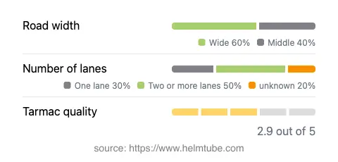
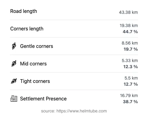
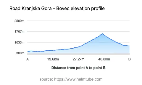
The Vršič Pass Road extends for approximately 43.4 km (27 miles), with a surface of asphalt that varies in quality from fair to moderate. Riders will encounter a mix of gently curved and very twisty sections, especially on the ascent and descent of the pass itself. The road features a combination of one-lane and two-lane segments, with the majority (about 53%) being two lanes, and the widest sections accounting for about 56% of the route. Narrow stretches are present, particularly on the switchbacks, which are a hallmark of the pass. The elevation ranges from 405 m (1,329 ft) at its lowest to 1,628 m (5,341 ft) at its highest point. Speed limits vary along the route, typically set at 30, 50, or 70 km/h (19, 31, or 43 mph), reflecting the technical nature of the road and the need for caution on sharp bends and in areas with limited visibility. The route passes through several settlements, including Trenta and the historic Ruska cesta (Russian Road), and offers access to numerous viewpoints overlooking the valleys and peaks of the Julian Alps.
Natural and Cultural Attractions Along the Route
The Vršič Pass Road is notable for its proximity to several natural and cultural landmarks. The road traverses Triglavski narodni park, Slovenia’s only national park, which is home to diverse alpine flora and fauna. The route closely follows the upper reaches of the Soča River for nearly half its length, offering riders frequent views of its turquoise waters. The pass itself is surrounded by the Julian Alps, with peaks such as Prisojnik and Mojstrovka visible from various viewpoints. The road also passes through the Spodnja Trenta valley and near the settlement of Trenta, both of which are gateways to hiking trails and alpine huts. Several marked viewpoints along the route provide opportunities to stop and appreciate the landscape. The historic Ruska cesta, built by Russian prisoners of war during World War I, adds a layer of historical interest to the journey. For those interested in the broader region, the town of Bovec serves as a base for outdoor activities, including rafting and hiking.
Seasonal Closures, Road Conditions, and Safety Considerations
The Vršič Pass Road is subject to seasonal closures due to snow and adverse weather conditions, typically from late autumn to spring. The pass is generally closed to all traffic, including motorcycles, during the winter months, with reopening dependent on snow clearance and weather stability. Riders are advised to check current road conditions before planning a trip, as sudden weather changes can affect accessibility. The road surface, while asphalted, can be uneven in places, especially on the switchbacks where cobblestone is sometimes used for traction. Caution is recommended on narrow and steep sections, particularly when descending toward Bovec. The route is popular with both motorcyclists and cyclists, so increased vigilance is necessary during peak tourist periods. For up-to-date information on road closures and conditions, consult the official Slovenian Traffic Information Center.
Tolls, Fees, and Practical Information for Motorcyclists
Currently, there is no toll or entrance fee specifically for motorcycles using the Vršič Pass Road. However, as the route passes through Triglavski narodni park, riders should be aware of potential changes to access regulations or fees in the future. Parking fees may apply at certain viewpoints or trailheads along the route. For the most current information on road tolls and entrance fees in Slovenia, refer to the official DARS vignette information page. It is advisable to carry cash for incidental expenses, as some remote locations may not accept card payments. Riders should also ensure their motorcycles are in good mechanical condition, as the technical nature of the road and the remote alpine environment can present challenges in the event of a breakdown.
Explore the Region: Roads Close By
Discover more amazing roads located near the route featured in this article. The list below highlights nearby routes that are perfect for extending your ride or planning your next adventure.
Ride the Best: Slovenia’s Top Motorcycle Roads
These are the best motorbiking roads in Slovenia. The list below shows links to articles about top-rated motorcycle routes in the country. Explore the most popular roads in Slovenia and plan your next unforgettable motorbike adventure.