Exploring the Pregrada–Miljana Route: A Technical Overview for Motorcyclists
Locals know best!
If you travel this road often or live close by you will be given a chance to provide your valuable rating soon! Sign in and stay connected.Location and General Context
Županijska cesta 2151 is situated in the Krapina-Zagorje County of Croatia, running between the settlements of Miljana and Pregrada. The road passes through several local streets, including Taborgradska ulica, Ulica Stjepana Radića, Ulica grofova Ratkaja, Trg Svetog Jurja, and Ulica Jurice Prejca. The region is characterized by gentle hills and a blend of agricultural and residential landscapes. Pregrada, the larger of the two endpoints, is a small town known for its historical sites and proximity to the Slovenian border. An interactive map showing the route can be found at the end of this article.
Technical Road Details
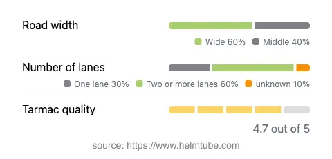
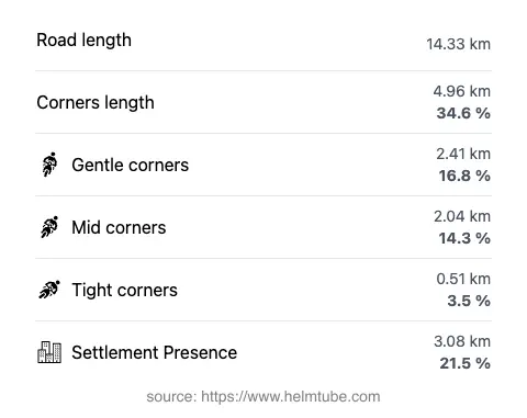
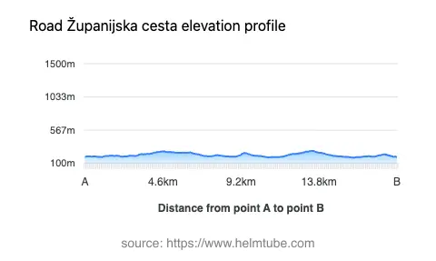
The total length of Županijska cesta 2151 is approximately 14.3 km (8.9 miles). The road surface is asphalt and is generally rated as very good, with most sections offering a smooth and reliable ride. The route features a moderate level of curviness, with gently winding segments interspersed with straighter stretches. The elevation ranges from 183 m (600 ft) at its lowest point to 276 m (906 ft) at its highest, resulting in mild elevation changes suitable for riders of all experience levels. The road is predominantly wide (about 54%), with a significant portion of medium width (36%), and only a small fraction is considered narrow (4%). Most of the route consists of two lanes (about 64%), while the remainder is single-lane (33%). Inhabited areas account for roughly 21.5% of the total distance, primarily near the settlements at each end.
Points of Interest Along the Route
While Županijska cesta 2151 itself is primarily a connector between Miljana and Pregrada, the area offers several attractions for those interested in local culture and history. In Pregrada, visitors can explore the Church of Saint Mary of the Assumption and the town's central square, Trg Svetog Jurja. The nearby Veliki Tabor Castle is a notable landmark, located a short ride from the route and offering insights into the region's medieval heritage. The surrounding countryside is dotted with vineyards and traditional Zagorje architecture, providing additional interest for those wishing to explore beyond the main road.
Road Closures and Seasonal Considerations
There are currently no known restrictions or closures for motorcycles on Županijska cesta 2151. The road remains open throughout the year, with no regular seasonal closures. However, as with many roads in northern Croatia, winter conditions can occasionally impact accessibility due to snow or ice, particularly on higher sections. Riders are advised to check local traffic updates before traveling during adverse weather conditions. Event-related closures are rare but may occur during local festivals or road maintenance works.
Tolls, Fees, and Practical Information
Županijska cesta 2151 does not currently require the payment of any tolls or entrance fees for motorcycles or other vehicles. Riders should be aware that toll conditions may change in the future, and it is advisable to consult official resources for the most up-to-date information. For comprehensive details on road tolls and fees in Croatia, visit the HAK (Croatian Automobile Club) website. The maximum speed limit along this route is generally 50 km/h (31 mph) in inhabited areas and 40 km/h (25 mph) in certain sections, as indicated by local signage. Adherence to posted speed limits is recommended due to occasional pedestrian and agricultural traffic.
Explore the Region: Roads Close By
Discover more amazing roads located near the route featured in this article. The list below highlights nearby routes that are perfect for extending your ride or planning your next adventure.
Ride the Best: Croatia’s Top Motorcycle Roads
These are the best motorbiking roads in Croatia. The list below shows links to articles about top-rated motorcycle routes in the country. Explore the most popular roads in Croatia and plan your next unforgettable motorbike adventure.