Exploring the 407 Gorenja vas – Vrhnika Route: A Motorcyclist’s Guide Through Polhograjsko Hribovje
Locals know best!
If you travel this road often or live close by you will be given a chance to provide your valuable rating soon! Sign in and stay connected.Location and Route Overview
The 407 Gorenja vas – Vrhnika road is situated in central Slovenia, connecting the towns of Gorenja vas and Vrhnika. The route traverses the Polhograjsko hribovje, a hilly region northwest of Ljubljana, and passes through several settlements including Gorenja Dobrava, Lučine, and Velika Ligojna. The road is positioned within the Ljubljanska kotlina basin, an area characterized by rolling hills and rural landscapes. The proximity to Žiri at the starting point and Vrhnika at the end makes this road accessible for riders coming from larger urban centers. An interactive map showing the precise route can be found at the end of this article.

Road Characteristics and Riding Experience
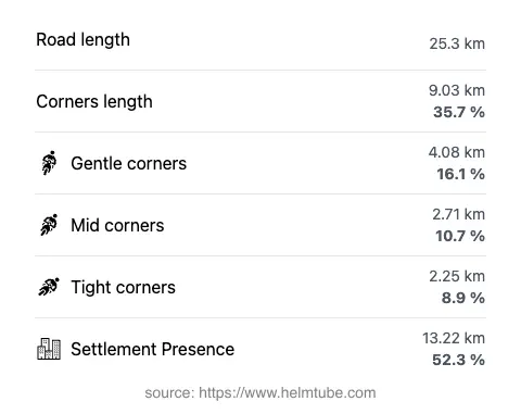
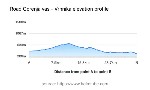
The 407 Gorenja vas – Vrhnika road extends for approximately 25.3 km (15.7 miles), with elevations ranging from 312 m (1,024 ft) to 683 m (2,241 ft). The road surface is asphalt and is generally rated as very good, offering a smooth ride for most motorcycles. Riders will encounter a mix of gently curved and moderately twisty sections, with the majority of the road being wide (about 67%), while some stretches are of medium width (26%) and a small portion is narrow (2%). The route features both one-lane (28%) and two-lane (63%) segments, with the remainder varying. Over half of the road passes through inhabited areas, providing a blend of rural and semi-urban riding environments. Speed limits vary along the route, typically set at 40, 50, 70, and 90 km/h (25, 31, 43, and 56 mph), depending on the proximity to settlements and road conditions.
Natural and Cultural Attractions Along the Route
This road passes through the Polhograjsko hribovje, a region known for its forested hills and traditional Slovenian rural landscapes. The area is not a national park in the strictest sense but is recognized for its natural value and is popular among hikers and cyclists. Notable settlements along the way, such as Gorenja vas and Vrhnika, offer opportunities to explore local culture and cuisine. The route’s proximity to the Ljubljanska kotlina basin provides access to a variety of outdoor activities and viewpoints, making it a worthwhile detour for riders interested in the natural and cultural heritage of central Slovenia.
Seasonal Accessibility and Road Closures
The 407 Gorenja vas – Vrhnika road is generally open to motorcycles year-round. However, due to its elevation and the hilly terrain of the Polhograjsko hribovje, occasional winter closures or restrictions may occur during periods of heavy snowfall or adverse weather. Riders are advised to check local traffic updates before planning a winter ride. There are no regular event-related closures reported for this route, but temporary disruptions may occur due to maintenance or local events in the settlements along the way.
Tolls, Fees, and Practical Information
There are currently no tolls or entrance fees required for motorcycles on the 407 Gorenja vas – Vrhnika road. Riders should be aware that toll conditions may change in the future, and it is advisable to consult official resources for the most up-to-date information. For further details on road tolls and fees in Slovenia, visit the DARS Motorway Company website. Fuel and basic services are available in the larger towns at either end of the route, but options are limited in the smaller settlements along the way.
Explore the Region: Roads Close By
Discover more amazing roads located near the route featured in this article. The list below highlights nearby routes that are perfect for extending your ride or planning your next adventure.
Ride the Best: Slovenia’s Top Motorcycle Roads
These are the best motorbiking roads in Slovenia. The list below shows links to articles about top-rated motorcycle routes in the country. Explore the most popular roads in Slovenia and plan your next unforgettable motorbike adventure.