Exploring the 630 Prem–Golac Road: A Motorcyclist’s Guide through Brkini, Slovenia
Locals know best!
If you travel this road often or live close by you will be given a chance to provide your valuable rating soon! Sign in and stay connected.Location and Regional Context
The 630 Prem–Golac road is situated in the Brkini region of southwestern Slovenia, connecting the settlements of Prem, Čelje, and Pregarje. The route lies within easy reach of the town of Ilirska Bistrica, which is approximately 7 km (4.3 miles) from the starting point and 9 km (5.6 miles) from the endpoint. Brkini is characterized by rolling hills, mixed forests, and a patchwork of small villages, offering a rural backdrop distinct from Slovenia’s more frequented alpine or coastal areas. An interactive map showing the 630 Prem–Golac road can be found at the end of this article.
Road Characteristics and Riding Experience
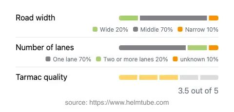
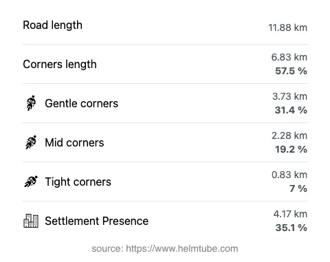
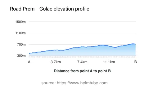
The 630 Prem–Golac road extends for approximately 11.9 km (7.4 miles), with an elevation range from 384 m (1,260 ft) to 722 m (2,369 ft). The road surface is asphalt, with a quality rating that can be described as average to good, though riders should be prepared for occasional rough patches. The route is moderately curvy, offering a mix of gently winding and more pronounced bends, making it suitable for riders who appreciate technical riding without the intensity of alpine passes. The road width varies, with the majority (about 70%) being of medium width, while narrower and wider sections are also present. Most of the route is single-lane, with some stretches accommodating two lanes. Approximately one-third of the road passes through inhabited areas, so caution is advised when riding through villages and near local traffic.
Natural Features and Attractions
The route briefly follows the course of the Reka River, also known as Vela voda or Timavo-Timava, for a short segment. This river is notable for its karstic characteristics and eventual disappearance underground, contributing to the unique hydrology of the region. Along the road, riders will encounter several viewpoints that offer expansive vistas over the Brkini hills and surrounding countryside. While these viewpoints are not formally developed tourist sites, they provide opportunities for rest and photography. The Brkini region itself is recognized for its traditional orchards and rural landscapes, which can be explored further in nearby villages. For more information about the region, visit the Brkini Wikipedia page.
Road Access, Closures, and Fees
The 630 Prem–Golac road is open to motorcycles throughout the year, with no regular seasonal closures reported. However, riders should be aware that winter conditions, such as snow or ice, may render the road hazardous or temporarily impassable, particularly at higher elevations. There are no known tolls or entrance fees for using this road, but toll conditions may change in the future. For up-to-date information on road tolls and regulations in Slovenia, consult the official DARS website.
Practical Considerations for Motorcyclists
Riders should approach the 630 Prem–Golac road with attention to changing road widths and surface conditions. The moderate curviness of the route allows for a relaxed pace, but vigilance is required in inhabited areas and on narrower sections. Services such as fuel and food are best accessed in Ilirska Bistrica, as facilities along the route itself are limited. The road’s rural setting means that wildlife crossings and agricultural vehicles are possible, especially during early morning or late afternoon hours. For those interested in extending their ride, the Brkini region offers additional minor roads and connections to the broader Primorska area. An interactive map of the 630 Prem–Golac road is available below for route planning and navigation.
Explore the Region: Roads Close By
Discover more amazing roads located near the route featured in this article. The list below highlights nearby routes that are perfect for extending your ride or planning your next adventure.
Ride the Best: Slovenia’s Top Motorcycle Roads
These are the best motorbiking roads in Slovenia. The list below shows links to articles about top-rated motorcycle routes in the country. Explore the most popular roads in Slovenia and plan your next unforgettable motorbike adventure.